Is the Aral Sea still shrinking?
When I was in university, I took a class called "Intro to International Development Studies". For that class, I researched and wrote an essay on the Aral Sea crisis in Central Asia. I learned a lot from writing that essay—I believe it's where I first encountered the concept of virtual water; I decided to revisit the topic for my blog.
My essay began with an introduction to the Aral Sea and its disastrous history in the 20th Century:
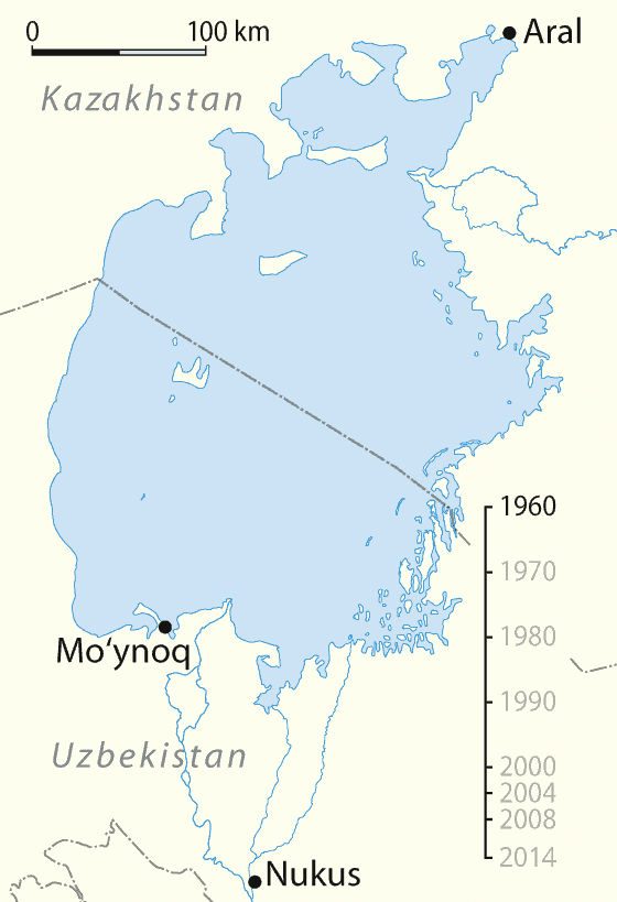
The Aral Sea is contained within Uzbekistan and Kazakhstan; its desiccation is known as “one of the world’s worst ecological disasters.” (Spoor and Krutov) The Aral Sea is fed by two rivers: the Amu Darya and the Syr Darya. Partial diversion—or total diversion, in some years—of these rivers to supply water for irrigation and other uses in the Central Asian states has resulted in not enough water reaching the Aral Sea to replace losses due to evaporation; the sea has been shrinking since 1960. This disaster is man-made. By examining water management practices in Uzbekistan, possible solutions can be found for their water needs and insight can be gained into the issues that other states face with water.
I explained the history of the shrinking Aral Sea in my essay as follows:
During the Soviet period, Uzbekistan’s economy was centrally controlled. Lenin issued a decree on “conquering vast deserts” that forced the Central Asian countries to expand their production of ‘white gold’ — cotton. Since Central Asia comprises a lot of arid and desert terrain, the expansion of agriculture required the expansion of irrigation. Until 1960, the level of irrigation seems to have been sustainable. Micklin estimates that there were almost five million hectares of irrigated land in Uzbekistan prior to 1960. Some of that land had first been irrigated more than three millennia ago; around two million hectares were irrigated by the time the Russian Tsar conquered Uzbekistan. The level of water withdrawals by 1960 did not seem to have an impact on the Aral Sea; water losses to irrigation were compensated for by the lessening of natural losses (evaporation, plant transpiration, filtration into the ground, and flooding). However, as the amount of irrigated land was increased by another one million hectares between 1960 and 1980, the natural compensation could no longer keep up and the Aral Sea began drying up. Part of the problem was that lands that were added to the irrigation network after 1960 were not very suitable for farming and thus required much more water to produce crops.
The Aral Sea used to be a vibrant lake. Now it is a shrunken puddle of brine. In 1960, it was the fourth largest lake in the world with an area of 66 900 km2 (for comparison, New Brunswick has an area of 72 908 km2 and the island of Sri Lanka has an area of 65 610 km2), and a volume of 1090 km3. The Aral Sea used to be inhabited by freshwater fish; it had an average salinity of 10 g/L in 1960. For comparison purposes, ocean water has an average salinity of 35 g/L. The current statistics (1998) show just how much the sea has deteriorated. In 1987, the Aral Sea split into two bodies of water : a small northern body of water that is totally within Kazakhstan’s territory, and a large southern sea that is shared by Uzbekistan and Kazakhstan. The combined area of the two seas was 31 541 km2 in 1998 —less than half of the 1960 area— and the combined volume had dropped to 236 km3—less than a quarter of what it had been. In the large sea, the water level has dropped by 17.8 m and is projected to keep dropping. There is some good news for the smaller northern sea, though. A dike, partly funded by the World Bank, has sealed the channel between the two seas. The water level in the smaller sea, which is fed by the Syr Darya (the larger sea is fed by the Amu Darya), is reportedly rising again , now that it is no longer losing water to the larger sea; naturally, the salinity has undergone a corresponding drop.
The consequences of the Aral Sea drying up were also covered in my essay:
The desiccation of the Aral Sea has had serious consequences for the health and livelihoods of those who live around it. Expanses of land that were formerly underneath the waters of the Aral Sea have now become exposed; they are covered in salts. Windstorms can pick up these salts and blow them all over the region. Some estimates put the amount of salt moved each year at 1.5 million tonnes! These salts, and the dust that is also swept into the air, have been confirmed to spread at least 400 km from the Aral Sea. The spreading of salt from the Aral Sea over a wide area has been blamed for damaging crops and degrading water supplies. Obviously, these effects are harmful to the economy of an agricultural country, as well as being detrimental to the health of the men, women and children who eat the produce and drink the water.
One of the issues I explored in my essay was the economic importance of water:
Water is crucial not only for life in Uzbekistan but for the economy as well. The importance of agriculture to the Uzbekistani economy is huge. And irrigation is crucial to agriculture in such a dry country. In 1990, 98% of the cultivated land was irrigated, including all the land used for cotton production. Irrigated agriculture provided 35% of Uzbekistan’s GDP, 60% of their foreign exchange income and 42% of their employment in 1996. Before the Aral Sea became an environmental disaster area, it also provided employment for many people. Micklin estimates that 60 000 jobs in Kazakhstan and Uzbekistan were attributable to the Aral Sea fishery, which has now disappeared. Usmanova states that in the 1950s, prior to the sea’s desiccation, there were resorts on the beaches of the Aral Sea and that high quality caviar was produced in the area. Needless to say, tourism and caviar production are no longer viable. The Aral Sea crisis has really hurt the economy of Uzbekistan.
Researching this essay was where I first learned about soil salinization (not to be confused with Stalinization) and water-logging and the problems they can cause in irrigated agriculture:
The Aral Sea crisis is not the only negative consequence of the water management practices of Uzbekistan. Another serious issue, in some parts of the country more than others, is soil salinization. Irrigation water (from rivers or groundwater), unlike rainwater, contains some dissolved salts. For most applications, the concentrations involved are so small that they are not a problem or are even beneficial. When this water is applied to crops, though, the water is taken up by the plant but the salts are left in the soil. After a period of time, there is a build up of salts around the roots of the plants. To correct for this, extra water must be applied to the field to wash the salts away or deeper into the ground. This wash water must then be disposed of since its salt concentration is too high for most uses. Irrigation water is not the only cause of salt build up around the roots of plants; minerals in the ground are drawn upward as plants take in water. They must also be washed away by excess water. This application of excess water, coupled with poor drainage of arable land, causes groundwater levels to rise.
One of my sources (Bouwer, Herman. “Integrated Water Management for the 21st Century: Problems and Solutions.” Journal of Irrigation and Drainage Engineering. 128.4 (2002): 193-202.) provided a compelling quote:
Inability to control groundwater below irrigated land has caused the demise of old civilizations and is still the reason why so much irrigated land in the world is losing productivity or is even being abandoned today (Postel 1999). [Reference in source]… Irrigation without groundwater control ultimately causes waterlogging and salinity problems.
Some of the research I came across while writing this essay had to do with conservation incentives from water pricing:
For both individual farms and entire countries there is a perception of “use it or lose it” toward water resources; entities believe that they must use their full allotment every year, even if they do not need it all, in order to maintain a claim to the same amount the next year. Until recently, water was a free resource in Uzbekistan; it was allotted by a quota system, but it did not have to be paid for. In one area of Uzbekistan, in 2000, charges of 0.11 Soum/m3 were levied (a Soum is the Uzbekistani unit of currency; the exchange rate was 1020 Soum/USD in 2005, less than a quarter of its value in 2001). This is well below the estimated real cost of 0.9 Soum/m3, and even further below the cost of irrigation water in California, where it can reach $75/1000 m3 (which converts to 76.5 Soum/m3 at the 2005 exchange rate). Since the price of water is set below cost, there is little incentive to use it efficiently; there are not economic incentives to improve water management practices in Uzbekistan
On a broader scale, some researchers had proposed a regional market for water:
Lerman, Garcia-Garcia and Wichelns suggest that a Central Asian water market would allow countries that manage to reduce their demand for water withdrawals from the Amu Darya or Syr Darya could “sell” that water to neighbouring countries who would then be allowed to withdraw more; maybe environmental groups could even “buy” some of the water and allocate it to the Aral Sea.
A program of this sort in Australia is described in Steven Solomon's book on water (and mentioned in my review).
As I mentioned above, researching for this essay is where I learned about "virtual water" and water footprints, which takes the idea of trading water—in an abstract sense—to a global level:
Through the concept of “Virtual water” it can be seen that 20% of the water diverted from the Aral Sea ends up in Europe. Virtual water is “The volume of water used to produce a commodity” ; it moves around the world (conceptually) as that commodity is traded. In analogy to the concept of an ecological footprint, it is possible to determine the “Water footprint” of each person on the earth, showing how much water it takes to sustain that person’s lifestyle, and where that water is being used. Water is used to produce cotton in Uzbekistan, but that cotton is mostly consumed outside of the country. ... It is only fair that consumers in the developed world would pay the true cost of production for the commodities they buy from the developing world.
The Aral Sea crisis was caused by over-use of water in Central Asia, but much of that over-use was to produce material for export, so from the perspective of virtual water, a lot of water was virtually exported from the basin. At a pittance of a price, at that.
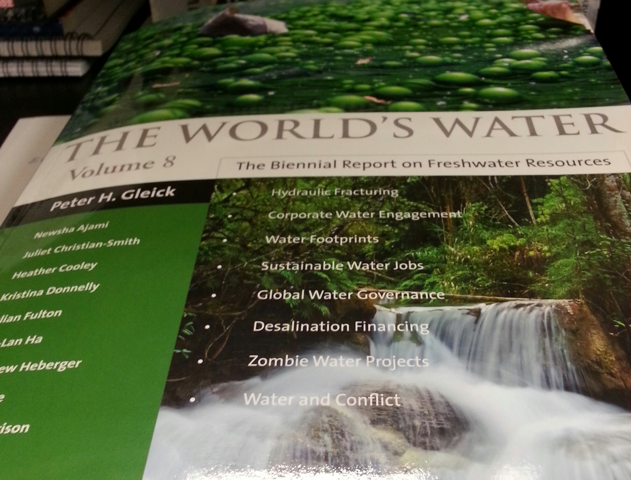
For more information on virtual water, I recently read the chapter on the topic from Volume 8 of The World's Water by the Pacific Institute. It explains the concept as follows:
[D]irect uses of water, however, are only part of the story. Water is also required to produce nearly everything we use and consume, from the food we eat and the clothes we wear to the technological devices that are integral to our modern society. Because this indirect water isn't visible in the product, it is also often referred to as "embedded," "embodied," or "virtual" water. A full measure, therefore, of the water footprint of an individual, industrial sector, or society is the combination of direct water use and the water used indirectly to provide the goods and services consumed.
It also provides some more in-depth examination and application of the concept:
The quantitative measure of a ... water footprint, by itself, might reveal little about the consequences or local impacts of that water use. Additional information (and often subjective evaluation) is required to estimate the impact of a water footprint. If the water consumed comes from areas where water is relatively abundant, the social and environmental impacts may be far less than for the same consumption from a region where water is scarce.
For agriculture, an important consideration when examining water footprints is whether the water used comes from rainwater or is extracted from surface or groundwater sources.
They also point out that trade flows both ways, and arid regions can "import" virtual water (by importing goods that are water-intensive to produce):
Trade is an important way in which countries can overcome local water scarcity by importing virtual water. But trade also provides a way in which distant water resources might be overexploited or mismanaged without the knowledge of the consumer
The Aral Sea provides a dramatic example, but these issues are relevant in other places as well:
- Lake Mead (above the Hoover Dam) has dropped to its lowest level ever
- In China, the intraprovincial trade in virtual water has been estimated at 109 Billion cubic metres per year
- A couple of weeks ago, I wrote a post about a project investigating water scarcity along the Rio Grande
To answer the question in the title, it seems that the Northern Aral Sea (in Kazakhstan) has been doing well since I wrote my essay, but the rest of it remains a disaster.
Finally, everyone loves GIFs, so I thought I'd link a great one of the Aral Sea from Wikipedia: