The Americas Before 1492
This post took a couple of weeks to research and put together. I hope it was worth the wait. It is a review of 1491: New Revelations of the Americas Before Columbus by Charles C. Mann. Well, it's not so much a review as it is a further exploration of the book's topic.
As the title indicates, 1491 is about the history of the Americas prior to permanent European settlement. I initially read this article by the author, and put it on my list to read someday. Now I have, and I really learned a lot from it.
At one point in 1491, Mann mentions a world history textbook that only spends 9 pages on the Americas prior to Columbus. He writes,
The thesis of the book in your hands is that Native American history merits more than nine pages.
Most people are probably aware of the Aztecs, Inca, and Mayans, but 1491 shows that their civilizations didn't come out of nowhere—Mesoamerica and the territory stretching from the Andes to the Peruvian coast each (with minimal contact between them) had a succession of city-states and empires to rival the ancient Mediterranean world.
Mann's book is divided into three parts:
- Numbers from Nowhere
- Very Old Bones
- Landscape with Figures
The first part asserts that indigenous populations were much higher than conventionally reckoned (the theory is that smallpox came with the earliest European explorers and all but de-populated many native communities before anyone started keeping accurate records). The second part argues for an earlier human presence than the Bering land bridge was thought to imply (see here and here for more information). The third part argues against the view that the Americas were a pristine wilderness prior to European settlement; rather, indigenous people had a distinct impact on the landscape. Fire was a notable tool for this purpose (e.g. to clear undergrowth and promote post-disturbance vegetation, and slash-and-char agriculture that enriched tropical soils).
Of course, proving these bold claims is far beyond the scope of a popular-level history. They do, however, provide a structure for telling some of the history of the Americas before 1492, when Columbus sailed the ocean blue.
Here are a couple of quotes from 1491 that I liked related to these organizing themes:
In the long run, Fenn says, the consequential finding is not that many people died but that many people lived.
And,
Until Columbus, Indians were a keystone species in most of the hemisphere. Annually burning undergrowth, clearing and replanting forests, building canals and raising fields, hunting bison and netting salmon, growing maize, manioc, and the Eastern Agricultural Complex, Native Americans had been managing their environment for thousands of years. As Cahokia shows, they made mistakes. But by and large they modified their landscapes in stable, supple, resilient ways.
Further Exploration
To explore further, I decided to look up some of the sites mentioned in 1491 in Google Earth. In many cases, there are features that can be seen in an aerial view, and Google Earth also offers some geo-located pictures. I also added some other pre-Columbian sites I was already aware of to make a collection of placemarks relevant to the archaeology of the Americas. My .kml file is at the bottom of this post. Before that, I've included screenshots, links, and quotes or discussion from 1491 for some of the notable sites.
Chan Chan
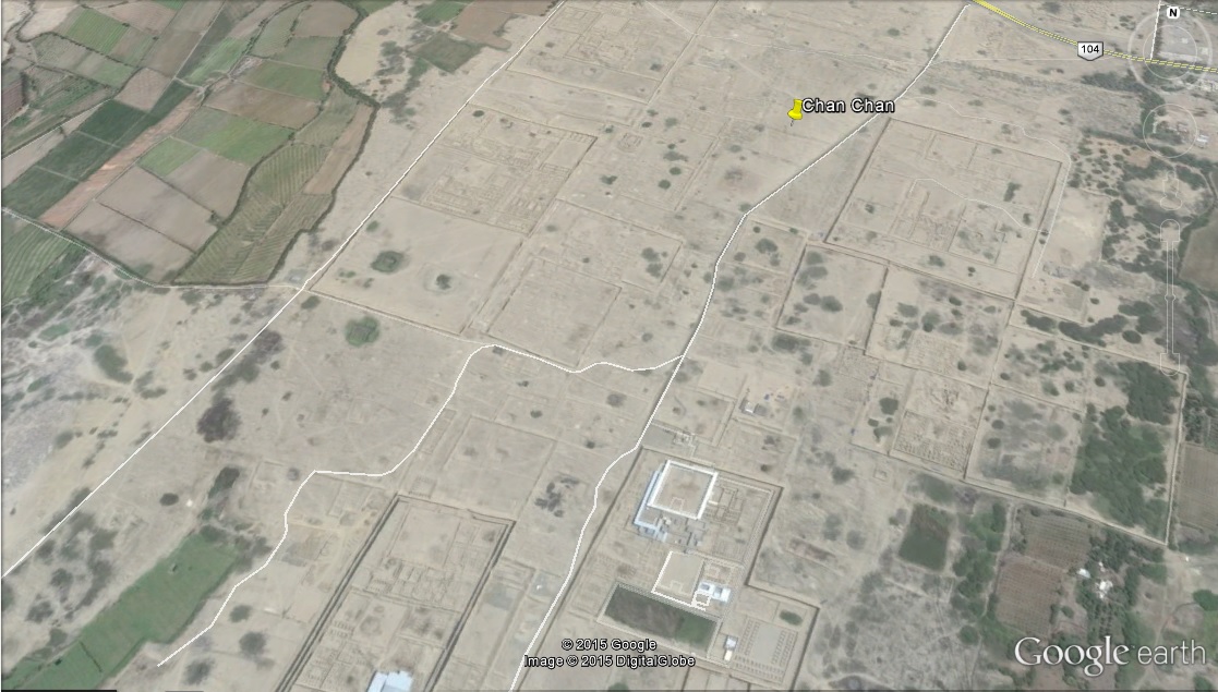
Chan Chan is an early site on the Peruvian coast.
The Beni
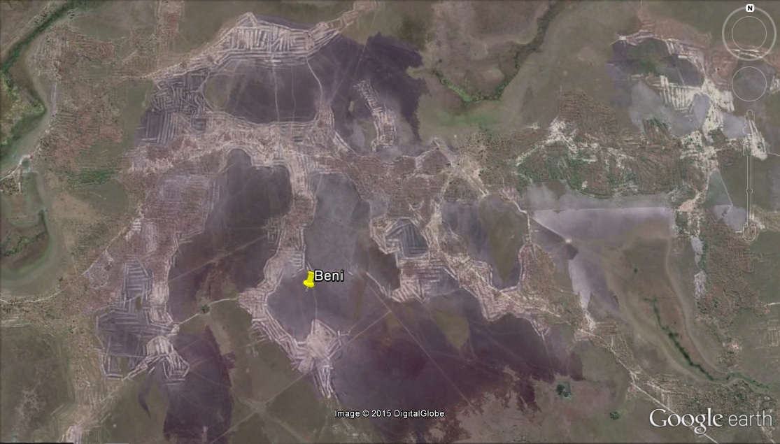
1491 opens with a discussion of raised fields and earthworks in the now sparsely-populated Beni savannah of Bolivia (I'm not sure if the location shown in this screenshot is ancient or more recent, but it looks like a photo in the book):
The Beni is a case in point. In addition to building roads, causeways, canals, dikes, reservoirs, mounds, raised agricultural fields, and possibly ball courts, Erickson has argued, the Indians who lived there before Columbus trapped fish in the seasonally flooded grassland.
Cahokia
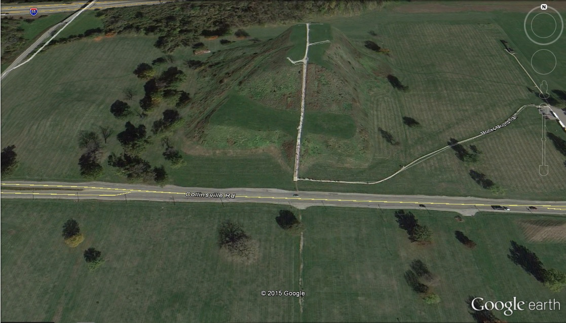
The Cahokia mounds are in the state of Illinois, very close to St. Louis. They comprise a number of earthen pyramids and mounds, that used to be at the center of a large city for its era:
Covering five square miles and housing at least fifteen thousand people, Cahokia was the biggest concentration of people north of the Rio Grande until the eighteenth century.
Chaco Canyon
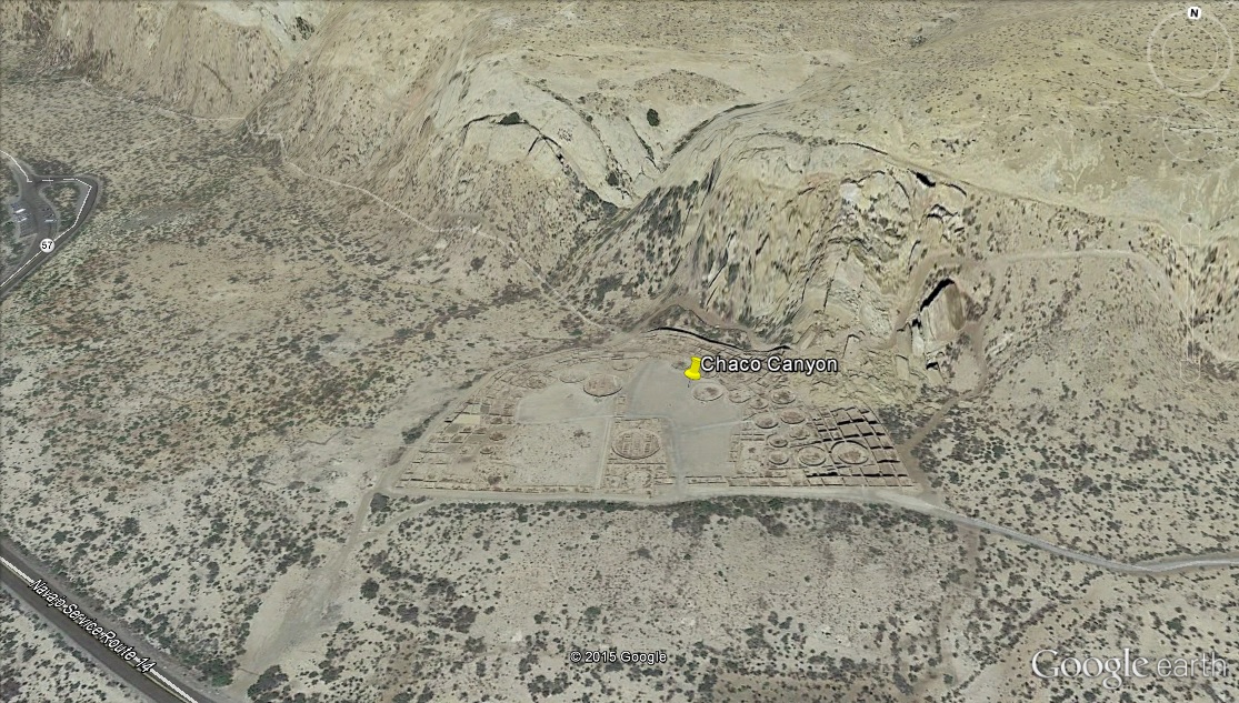
I don't recall that Chaco Canyon (or the nearby Mesa Verde site) was discussed in 1491, but I wanted to include another place in the United States in this post.
Caral
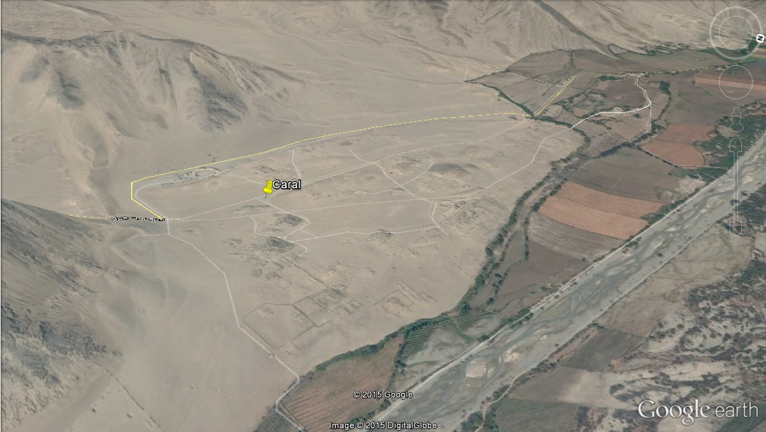
Caral is a site near the Peruvian coast in the Norte Chico:
Nonetheless, visitors to Andean history note certain ways of doing things that recur in ways striking to the outsider, sometimes in one variant, sometimes in another, like the themes in a jazz improvisation. The primacy of exchange over a wide area, the penchant for collective, festive civic work projects, the high valuation of textiles and textile technology—Norte Chico, it seems possible to say, set the template for all of them.
An aspect to 1491 that I found really interesting was the author making the point that agriculture and the rise of cities (see here occurred independently in the New World, without any contact or exchange with the wellsprings of human civilization in the Old World: Mesopotamia, Nile, Indus, & Yellow River. Interestingly, those civilizations are all associated with flood irrigation of staple foods along major rivers, while the Peruvian littoral cultures got most of their food from the sea (while focussing their agriculture on cotton for textiles).
Wari
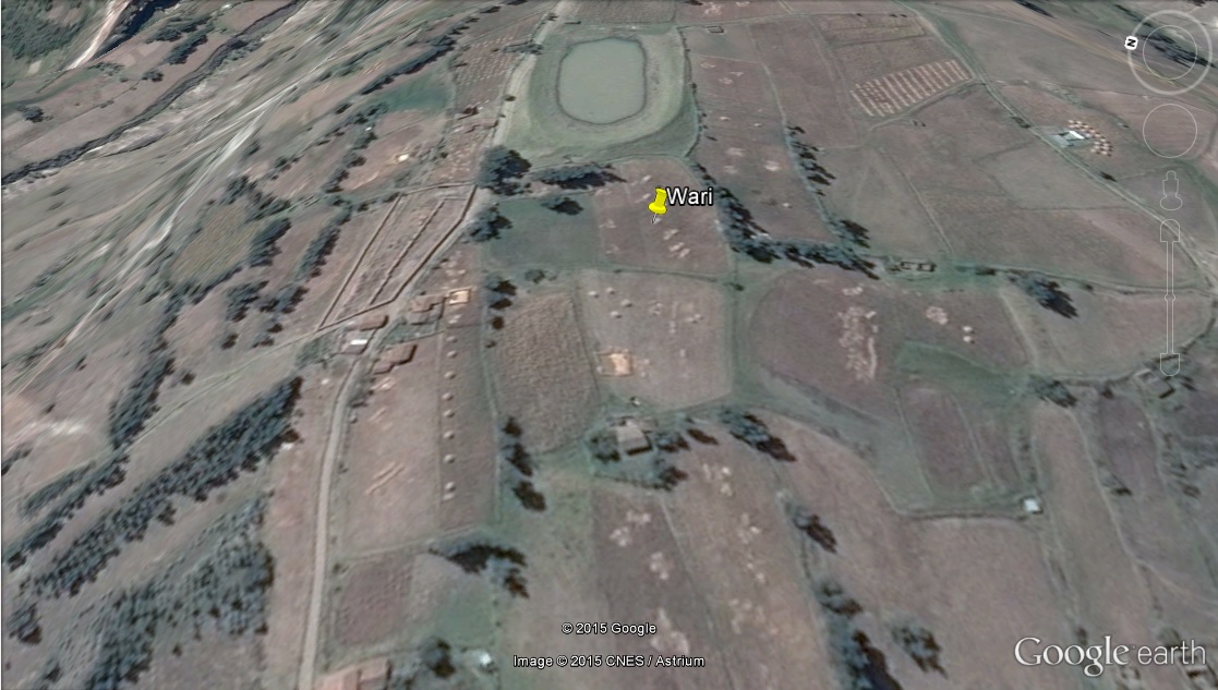
The Wari were yet another culture in Peru, known for spreading terrace agriculture. They bordered with Tiwanaku in the Altiplano, also discussed in 1491.
Mutal
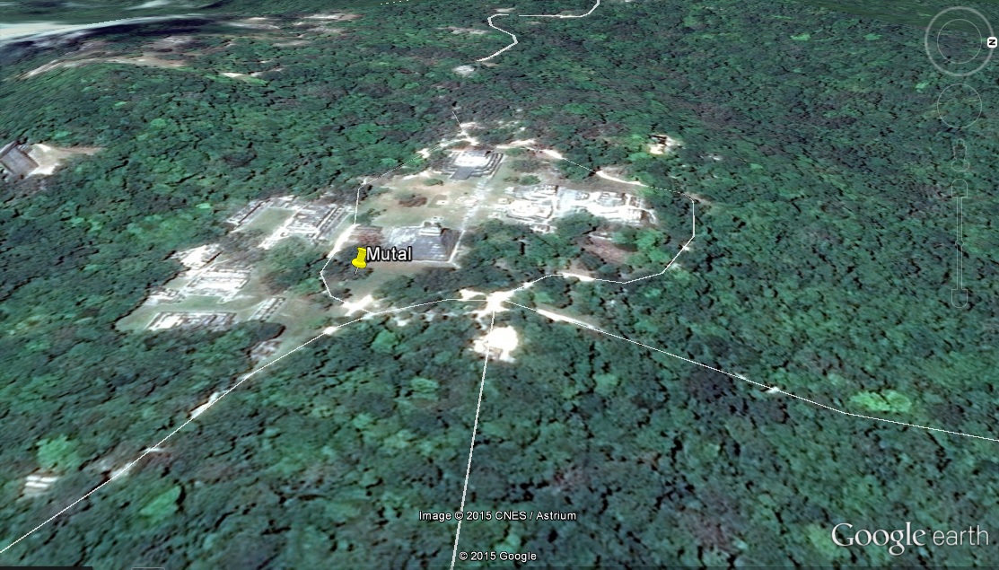
Mutal, also known as Tikal, is one of the Mayan cities discussed in 1491.
I take a keen interest in learning how different people have met their water resource challenges. The Maya are interesting in that regard. The Yucatan peninsula where they lived gets plenty of rain, but it quickly infiltrates down into aquifers, many of which are apparently brackish. They effectively had to turn surface water bodies into cisterns, as explained by Mann:
Most of the salt occurred in the sediments on the swamp bottoms. To make the water potable, the Maya laid a layer of curshed limestone atop the sediments, effectively paving over the salt. As the researchers noted, the work had to be done before the Maya could move in and set up their milpas and gardens. "Permanent, year-round populations could be established only in the presence of an anticipatory engineering of water supplies." The Maya heartland, in other words, was a network of artificially habitable terrestrial islands.
Monte Alban
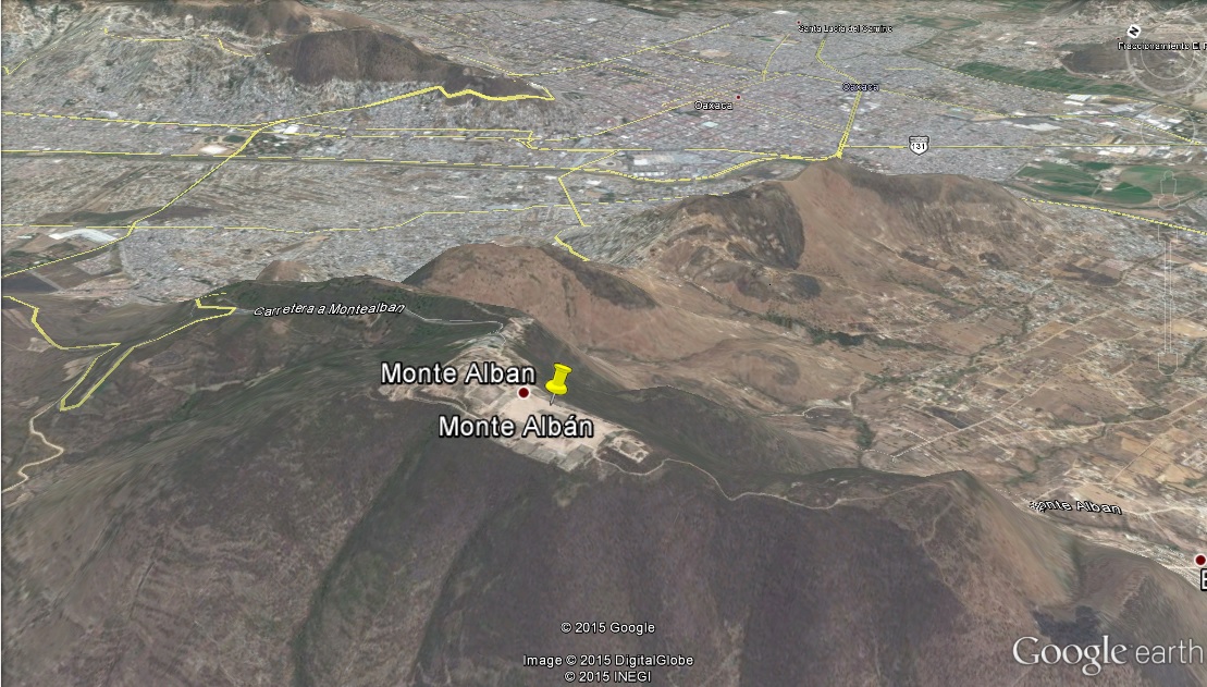
Monte Alban, in Oaxaca, Mexico, was built on the cultivation of maize/corn, which is still a staple crop in that area today.
A huge number of crops eaten today were developed in the Americas, including potatoes in the Andes, Manioc/cassava/tapioca in the Amazon, and sunflowers in the U.S. southeast, as well as tomatoes, chilis, squash, etc.:
One writer has estimated that Indians developed three-fifths of the crops now in cultivation, most of them in Mesoamerica.
These crops spread all over the world in the post-1492 "Columbian exchange".
Unlike wheat, maize is very different from its closest wild relative; developing it for agriculture was an amazing achievement by ancient people of Mesoamerica. I really liked this quote from 1491 on the topic:
"To get corn out of teosinte is so—you couldn't get a grant to do that now, because it would sound so crazy." She added, "Somebody who did that today would get a Nobel Prize! If their lab didn't get shut down by Greenpeace, I mean."
If this post caught your interest, I'd recommend reading 1491, or following some of the links I've included, or loading the set of placemarks I made (see below) into Google Earth to take a look.
Save the following data as 1491.kml and open it in Google Earth:
<?xml version="1.0" encoding="UTF-8"?>
<kml xmlns="http://www.opengis.net/kml/2.2" xmlns:gx="http://www.google.com/kml/ext/2.2" xmlns:kml="http://www.opengis.net/kml/2.2" xmlns:atom="http://www.w3.org/2005/Atom">
<Document>
	<name>1491.kml</name>
	<StyleMap id="m_ylw-pushpin00">
		<Pair>
			<key>normal</key>
			<styleUrl>#s_ylw-pushpin00</styleUrl>
		</Pair>
		<Pair>
			<key>highlight</key>
			<styleUrl>#s_ylw-pushpin_hl1</styleUrl>
		</Pair>
	</StyleMap>
	<Style id="s_ylw-pushpin0">
		<IconStyle>
			<scale>1.1</scale>
			<Icon>
				<href>http://maps.google.com/mapfiles/kml/pushpin/ylw-pushpin.png</href>
			</Icon>
			<hotSpot x="20" y="2" xunits="pixels" yunits="pixels"/>
		</IconStyle>
	</Style>
	<StyleMap id="m_ylw-pushpin">
		<Pair>
			<key>normal</key>
			<styleUrl>#s_ylw-pushpin0</styleUrl>
		</Pair>
		<Pair>
			<key>highlight</key>
			<styleUrl>#s_ylw-pushpin_hl0</styleUrl>
		</Pair>
	</StyleMap>
	<StyleMap id="m_ylw-pushpin0">
		<Pair>
			<key>normal</key>
			<styleUrl>#s_ylw-pushpin</styleUrl>
		</Pair>
		<Pair>
			<key>highlight</key>
			<styleUrl>#s_ylw-pushpin_hl</styleUrl>
		</Pair>
	</StyleMap>
	<Style id="s_ylw-pushpin_hl">
		<IconStyle>
			<scale>1.3</scale>
			<Icon>
				<href>http://maps.google.com/mapfiles/kml/pushpin/ylw-pushpin.png</href>
			</Icon>
			<hotSpot x="20" y="2" xunits="pixels" yunits="pixels"/>
		</IconStyle>
	</Style>
	<Style id="s_ylw-pushpin_hl0">
		<IconStyle>
			<scale>1.3</scale>
			<Icon>
				<href>http://maps.google.com/mapfiles/kml/pushpin/ylw-pushpin.png</href>
			</Icon>
			<hotSpot x="20" y="2" xunits="pixels" yunits="pixels"/>
		</IconStyle>
	</Style>
	<Style id="s_ylw-pushpin">
		<IconStyle>
			<scale>1.1</scale>
			<Icon>
				<href>http://maps.google.com/mapfiles/kml/pushpin/ylw-pushpin.png</href>
			</Icon>
			<hotSpot x="20" y="2" xunits="pixels" yunits="pixels"/>
		</IconStyle>
	</Style>
	<StyleMap id="m_ylw-pushpin01">
		<Pair>
			<key>normal</key>
			<styleUrl>#s_ylw-pushpin1</styleUrl>
		</Pair>
		<Pair>
			<key>highlight</key>
			<styleUrl>#s_ylw-pushpin_hl00</styleUrl>
		</Pair>
	</StyleMap>
	<Style id="s_ylw-pushpin1">
		<IconStyle>
			<scale>1.1</scale>
			<Icon>
				<href>http://maps.google.com/mapfiles/kml/pushpin/ylw-pushpin.png</href>
			</Icon>
			<hotSpot x="20" y="2" xunits="pixels" yunits="pixels"/>
		</IconStyle>
	</Style>
	<Style id="s_ylw-pushpin_hl00">
		<IconStyle>
			<scale>1.3</scale>
			<Icon>
				<href>http://maps.google.com/mapfiles/kml/pushpin/ylw-pushpin.png</href>
			</Icon>
			<hotSpot x="20" y="2" xunits="pixels" yunits="pixels"/>
		</IconStyle>
	</Style>
	<Style id="s_ylw-pushpin_hl1">
		<IconStyle>
			<scale>1.3</scale>
			<Icon>
				<href>http://maps.google.com/mapfiles/kml/pushpin/ylw-pushpin.png</href>
			</Icon>
			<hotSpot x="20" y="2" xunits="pixels" yunits="pixels"/>
		</IconStyle>
	</Style>
	<Style id="s_ylw-pushpin00">
		<IconStyle>
			<scale>1.1</scale>
			<Icon>
				<href>http://maps.google.com/mapfiles/kml/pushpin/ylw-pushpin.png</href>
			</Icon>
			<hotSpot x="20" y="2" xunits="pixels" yunits="pixels"/>
		</IconStyle>
	</Style>
	<Folder>
		<name>1491</name>
		<description>Archaeology of the Americas</description>
		<Placemark>
			<name>San Jose Mogote</name>
			<LookAt>
				<longitude>-96.80287257782301</longitude>
				<latitude>17.1672620453285</latitude>
				<altitude>0</altitude>
				<heading>6.815110550722383e-005</heading>
				<tilt>42.20918335577277</tilt>
				<range>447.8060430653176</range>
				<gx:altitudeMode>relativeToSeaFloor</gx:altitudeMode>
			</LookAt>
			<styleUrl>#m_ylw-pushpin0</styleUrl>
			<Point>
				<gx:drawOrder>1</gx:drawOrder>
				<coordinates>-96.80287257782301,17.16726204532849,0</coordinates>
			</Point>
		</Placemark>
		<Placemark>
			<name>Monte Alban</name>
			<LookAt>
				<longitude>-96.76768740977526</longitude>
				<latitude>17.04334094011087</latitude>
				<altitude>0</altitude>
				<heading>-0.0006520104650386344</heading>
				<tilt>30.22222248565914</tilt>
				<range>786.8903063806389</range>
				<gx:altitudeMode>relativeToSeaFloor</gx:altitudeMode>
			</LookAt>
			<styleUrl>#m_ylw-pushpin0</styleUrl>
			<Point>
				<gx:drawOrder>1</gx:drawOrder>
				<coordinates>-96.76768740977526,17.04334094011087,0</coordinates>
			</Point>
		</Placemark>
		<Placemark>
			<name>Tres Zapatoes</name>
			<LookAt>
				<longitude>-95.44100220855458</longitude>
				<latitude>18.4657309122351</latitude>
				<altitude>0</altitude>
				<heading>-0.4269850873785462</heading>
				<tilt>23.00811558336335</tilt>
				<range>328.7786920850747</range>
				<gx:altitudeMode>relativeToSeaFloor</gx:altitudeMode>
			</LookAt>
			<styleUrl>#m_ylw-pushpin0</styleUrl>
			<Point>
				<gx:drawOrder>1</gx:drawOrder>
				<coordinates>-95.44100220855458,18.4657309122351,0</coordinates>
			</Point>
		</Placemark>
		<Placemark>
			<name>La Venta</name>
			<LookAt>
				<longitude>-94.04105238722164</longitude>
				<latitude>18.10299513319882</latitude>
				<altitude>0</altitude>
				<heading>-0.0007543129560956284</heading>
				<tilt>31.10805835887881</tilt>
				<range>334.9583459232894</range>
				<gx:altitudeMode>relativeToSeaFloor</gx:altitudeMode>
			</LookAt>
			<styleUrl>#m_ylw-pushpin0</styleUrl>
			<Point>
				<gx:drawOrder>1</gx:drawOrder>
				<coordinates>-94.04105238722164,18.10299513319882,0</coordinates>
			</Point>
		</Placemark>
		<Placemark>
			<name>Mutal</name>
			<LookAt>
				<longitude>-89.62268975267108</longitude>
				<latitude>17.22178382216051</latitude>
				<altitude>0</altitude>
				<heading>-1.729172579048898</heading>
				<tilt>26.03507025383745</tilt>
				<range>545.7270776425125</range>
				<gx:altitudeMode>relativeToSeaFloor</gx:altitudeMode>
			</LookAt>
			<styleUrl>#m_ylw-pushpin0</styleUrl>
			<Point>
				<gx:drawOrder>1</gx:drawOrder>
				<coordinates>-89.62268975267108,17.22178382216051,0</coordinates>
			</Point>
		</Placemark>
		<Placemark>
			<name>Paramonga</name>
			<LookAt>
				<longitude>-77.84093996778779</longitude>
				<latitude>-10.6529583834169</latitude>
				<altitude>0</altitude>
				<heading>1.454269307334978</heading>
				<tilt>52.27821408582482</tilt>
				<range>256.3391681637223</range>
				<gx:altitudeMode>relativeToSeaFloor</gx:altitudeMode>
			</LookAt>
			<styleUrl>#m_ylw-pushpin0</styleUrl>
			<Point>
				<gx:drawOrder>1</gx:drawOrder>
				<coordinates>-77.84093996778779,-10.6529583834169,0</coordinates>
			</Point>
		</Placemark>
		<Placemark>
			<name>Aspero</name>
			<LookAt>
				<longitude>-77.74086653335924</longitude>
				<latitude>-10.81536441176384</latitude>
				<altitude>0</altitude>
				<heading>1.409600860127882</heading>
				<tilt>57.19389240241262</tilt>
				<range>223.2265270139798</range>
				<gx:altitudeMode>relativeToSeaFloor</gx:altitudeMode>
			</LookAt>
			<styleUrl>#m_ylw-pushpin0</styleUrl>
			<Point>
				<gx:drawOrder>1</gx:drawOrder>
				<coordinates>-77.74086653335924,-10.81536441176384,0</coordinates>
			</Point>
		</Placemark>
		<Placemark>
			<name>Qusqo</name>
			<LookAt>
				<longitude>-71.98166835226019</longitude>
				<latitude>-13.5082906894682</latitude>
				<altitude>0</altitude>
				<heading>0.08012846987355889</heading>
				<tilt>49.65426950013979</tilt>
				<range>419.2615597912032</range>
				<gx:altitudeMode>relativeToSeaFloor</gx:altitudeMode>
			</LookAt>
			<styleUrl>#m_ylw-pushpin0</styleUrl>
			<Point>
				<gx:drawOrder>1</gx:drawOrder>
				<coordinates>-71.9816683522602,-13.5082906894682,0</coordinates>
			</Point>
		</Placemark>
		<Placemark>
			<name>Nazca</name>
			<LookAt>
				<longitude>-75.14873562852193</longitude>
				<latitude>-14.69169301934516</latitude>
				<altitude>0</altitude>
				<heading>1.178567327710118</heading>
				<tilt>54.0459900349788</tilt>
				<range>346.6267124651576</range>
				<gx:altitudeMode>relativeToSeaFloor</gx:altitudeMode>
			</LookAt>
			<styleUrl>#m_ylw-pushpin0</styleUrl>
			<Point>
				<gx:drawOrder>1</gx:drawOrder>
				<coordinates>-75.14893683845267,-14.69217775965668,0</coordinates>
			</Point>
		</Placemark>
		<Placemark>
			<name>Cahokia</name>
			<Camera>
				<longitude>-90.06315893386014</longitude>
				<latitude>38.64826440044322</latitude>
				<altitude>2827.0065742965</altitude>
				<heading>-3.073883502384003</heading>
				<tilt>8.954269181745898</tilt>
				<roll>0.7473226740676868</roll>
				<gx:altitudeMode>relativeToSeaFloor</gx:altitudeMode>
			</Camera>
			<styleUrl>#m_ylw-pushpin00</styleUrl>
			<Point>
				<gx:drawOrder>1</gx:drawOrder>
				<coordinates>-90.0634366872733,38.65230365369325,0</coordinates>
			</Point>
		</Placemark>
		<Placemark>
			<name>Kaan</name>
			<LookAt>
				<longitude>-89.51842754715267</longitude>
				<latitude>18.85757165332288</latitude>
				<altitude>0</altitude>
				<heading>-4.002508464037462</heading>
				<tilt>26.51505460151402</tilt>
				<range>453.2212440763219</range>
				<gx:altitudeMode>relativeToSeaFloor</gx:altitudeMode>
			</LookAt>
			<styleUrl>#m_ylw-pushpin00</styleUrl>
			<Point>
				<gx:drawOrder>1</gx:drawOrder>
				<coordinates>-89.51842754715267,18.85757165332288,0</coordinates>
			</Point>
		</Placemark>
		<Placemark>
			<name>Caral</name>
			<LookAt>
				<longitude>-77.51938262759255</longitude>
				<latitude>-10.88973586716448</latitude>
				<altitude>0</altitude>
				<heading>13.21798045373956</heading>
				<tilt>57.445525084978</tilt>
				<range>1725.383227402629</range>
				<gx:altitudeMode>relativeToSeaFloor</gx:altitudeMode>
			</LookAt>
			<styleUrl>#m_ylw-pushpin00</styleUrl>
			<Point>
				<gx:drawOrder>1</gx:drawOrder>
				<coordinates>-77.5213181842896,-10.89430651111657,0</coordinates>
			</Point>
		</Placemark>
		<Placemark>
			<name>Huaricanga</name>
			<LookAt>
				<longitude>-77.7527437415942</longitude>
				<latitude>-10.49126937502171</latitude>
				<altitude>0</altitude>
				<heading>13.23305441429519</heading>
				<tilt>37.46362748608735</tilt>
				<range>1065.743899219597</range>
				<gx:altitudeMode>relativeToSeaFloor</gx:altitudeMode>
			</LookAt>
			<styleUrl>#m_ylw-pushpin00</styleUrl>
			<Point>
				<gx:drawOrder>1</gx:drawOrder>
				<coordinates>-77.7527437415942,-10.49126937502171,0</coordinates>
			</Point>
		</Placemark>
		<Placemark>
			<name>Beni</name>
			<LookAt>
				<longitude>-65.52974116491869</longitude>
				<latitude>-13.22822263850727</latitude>
				<altitude>0</altitude>
				<heading>10.46918881379472</heading>
				<tilt>61.31792692437963</tilt>
				<range>1050.470162568095</range>
				<gx:altitudeMode>relativeToSeaFloor</gx:altitudeMode>
			</LookAt>
			<styleUrl>#m_ylw-pushpin00</styleUrl>
			<Point>
				<gx:drawOrder>1</gx:drawOrder>
				<coordinates>-65.52974116491869,-13.22822263850728,0</coordinates>
			</Point>
		</Placemark>
		<Placemark>
			<name>Tiwanaku</name>
			<LookAt>
				<longitude>-68.67288880105703</longitude>
				<latitude>-16.55616632520821</latitude>
				<altitude>0</altitude>
				<heading>10.89877911675524</heading>
				<tilt>26.28487540926983</tilt>
				<range>353.1444032422984</range>
				<gx:altitudeMode>relativeToSeaFloor</gx:altitudeMode>
			</LookAt>
			<styleUrl>#m_ylw-pushpin00</styleUrl>
			<Point>
				<gx:drawOrder>1</gx:drawOrder>
				<coordinates>-68.67288880105704,-16.55616632520821,0</coordinates>
			</Point>
		</Placemark>
		<Placemark>
			<name>Chaco Canyon</name>
			<LookAt>
				<longitude>-107.9614873755426</longitude>
				<latitude>36.06072011008603</latitude>
				<altitude>0</altitude>
				<heading>-0.004287180824198798</heading>
				<tilt>50.84303085299658</tilt>
				<range>245.8539224284887</range>
				<gx:altitudeMode>relativeToSeaFloor</gx:altitudeMode>
			</LookAt>
			<styleUrl>#m_ylw-pushpin00</styleUrl>
			<Point>
				<gx:drawOrder>1</gx:drawOrder>
				<coordinates>-107.9614873755426,36.06072011008603,0</coordinates>
			</Point>
		</Placemark>
		<Placemark>
			<name>Mesa Verde</name>
			<LookAt>
				<longitude>-108.4741817286265</longitude>
				<latitude>37.16667711145212</latitude>
				<altitude>0</altitude>
				<heading>-5.799132498951076</heading>
				<tilt>57.65310938492043</tilt>
				<range>1882.992275342969</range>
				<gx:altitudeMode>relativeToSeaFloor</gx:altitudeMode>
			</LookAt>
			<styleUrl>#m_ylw-pushpin00</styleUrl>
			<Point>
				<gx:drawOrder>1</gx:drawOrder>
				<coordinates>-108.4741817286265,37.16667711145212,0</coordinates>
			</Point>
		</Placemark>
		<Placemark>
			<name>Taos Pueblo</name>
			<LookAt>
				<longitude>-105.5463019446819</longitude>
				<latitude>36.43855879840753</latitude>
				<altitude>0</altitude>
				<heading>1.41272572580886</heading>
				<tilt>17.46163833272059</tilt>
				<range>543.6650516967342</range>
				<gx:altitudeMode>relativeToSeaFloor</gx:altitudeMode>
			</LookAt>
			<styleUrl>#m_ylw-pushpin00</styleUrl>
			<Point>
				<gx:drawOrder>1</gx:drawOrder>
				<coordinates>-105.5463019446819,36.43855879840753,0</coordinates>
			</Point>
		</Placemark>
		<Placemark>
			<name>Hopewell</name>
			<LookAt>
				<longitude>-83.00434686881337</longitude>
				<latitude>39.3762319438718</latitude>
				<altitude>0</altitude>
				<heading>5.218268554784251</heading>
				<tilt>50.25881282936177</tilt>
				<range>499.4490860071894</range>
				<gx:altitudeMode>relativeToSeaFloor</gx:altitudeMode>
			</LookAt>
			<styleUrl>#m_ylw-pushpin00</styleUrl>
			<Point>
				<gx:drawOrder>1</gx:drawOrder>
				<coordinates>-83.00434686881337,39.37623194387181,0</coordinates>
			</Point>
		</Placemark>
		<Placemark>
			<name>Chichen Itza</name>
			<LookAt>
				<longitude>-88.56895689045508</longitude>
				<latitude>20.68278877501239</latitude>
				<altitude>0</altitude>
				<heading>3.647181568357285</heading>
				<tilt>21.82980973654144</tilt>
				<range>302.0750604784279</range>
				<gx:altitudeMode>relativeToSeaFloor</gx:altitudeMode>
			</LookAt>
			<styleUrl>#m_ylw-pushpin01</styleUrl>
			<Point>
				<gx:drawOrder>1</gx:drawOrder>
				<coordinates>-88.5689568904551,20.68278877501239,0</coordinates>
			</Point>
		</Placemark>
		<Placemark>
			<name>Teotihuacan</name>
			<LookAt>
				<longitude>-98.84435090435699</longitude>
				<latitude>19.68544158910418</latitude>
				<altitude>0</altitude>
				<heading>0.08463055260068339</heading>
				<tilt>9.5416086343467</tilt>
				<range>2607.185825547188</range>
				<gx:altitudeMode>relativeToSeaFloor</gx:altitudeMode>
			</LookAt>
			<styleUrl>#m_ylw-pushpin01</styleUrl>
			<Point>
				<gx:drawOrder>1</gx:drawOrder>
				<coordinates>-98.84435090435697,19.68544158910418,0</coordinates>
			</Point>
		</Placemark>
		<Placemark>
			<name>Tenochtitlan</name>
			<LookAt>
				<longitude>-99.13319219767502</longitude>
				<latitude>19.43278683844401</latitude>
				<altitude>0</altitude>
				<heading>-1.719093064727691</heading>
				<tilt>26.43970673116971</tilt>
				<range>408.495236817251</range>
				<gx:altitudeMode>relativeToSeaFloor</gx:altitudeMode>
			</LookAt>
			<styleUrl>#m_ylw-pushpin</styleUrl>
			<Point>
				<gx:drawOrder>1</gx:drawOrder>
				<coordinates>-99.13319219767502,19.43278683844401,0</coordinates>
			</Point>
		</Placemark>
		<Placemark>
			<name>Serpent Mound</name>
			<LookAt>
				<longitude>-83.43028154407884</longitude>
				<latitude>39.02564618143839</latitude>
				<altitude>0</altitude>
				<heading>0.000634717631807307</heading>
				<tilt>7.403032944172875</tilt>
				<range>822.5234858267163</range>
				<gx:altitudeMode>relativeToSeaFloor</gx:altitudeMode>
			</LookAt>
			<styleUrl>#m_ylw-pushpin0</styleUrl>
			<Point>
				<gx:drawOrder>1</gx:drawOrder>
				<coordinates>-83.43028154407884,39.02564618143839,0</coordinates>
			</Point>
		</Placemark>
		<Placemark>
			<name>Adena</name>
			<LookAt>
				<longitude>-83.01412284633551</longitude>
				<latitude>39.35266963261049</latitude>
				<altitude>0</altitude>
				<heading>0.0259302943563606</heading>
				<tilt>21.28349822619127</tilt>
				<range>1554.567195284135</range>
				<gx:altitudeMode>relativeToSeaFloor</gx:altitudeMode>
			</LookAt>
			<styleUrl>#m_ylw-pushpin0</styleUrl>
			<Point>
				<gx:drawOrder>1</gx:drawOrder>
				<coordinates>-83.01412284633553,39.35266963261049,0</coordinates>
			</Point>
		</Placemark>
		<Placemark>
			<name>Poverty Point</name>
			<LookAt>
				<longitude>-91.40653898026828</longitude>
				<latitude>32.63435074750087</latitude>
				<altitude>0</altitude>
				<heading>-4.893681813281717</heading>
				<tilt>19.13204761766335</tilt>
				<range>1714.845156144372</range>
				<gx:altitudeMode>relativeToSeaFloor</gx:altitudeMode>
			</LookAt>
			<styleUrl>#m_ylw-pushpin0</styleUrl>
			<Point>
				<gx:drawOrder>1</gx:drawOrder>
				<coordinates>-91.40653898026829,32.63435074750087,0</coordinates>
			</Point>
		</Placemark>
		<Placemark>
			<name>Marajo</name>
			<LookAt>
				<longitude>-49.65828522229182</longitude>
				<latitude>-1.104213645901046</latitude>
				<altitude>0</altitude>
				<heading>6.285842971231553</heading>
				<tilt>0</tilt>
				<range>298210.3552412659</range>
				<gx:altitudeMode>relativeToSeaFloor</gx:altitudeMode>
			</LookAt>
			<styleUrl>#m_ylw-pushpin0</styleUrl>
			<Point>
				<gx:drawOrder>1</gx:drawOrder>
				<coordinates>-49.65828522229182,-1.104213645901046,0</coordinates>
			</Point>
		</Placemark>
		<Placemark>
			<name>Painted Rock Cave</name>
			<LookAt>
				<longitude>-54.18055522021967</longitude>
				<latitude>-2.014301465244372</latitude>
				<altitude>0</altitude>
				<heading>6.541610464859001</heading>
				<tilt>16.3345723240546</tilt>
				<range>3348.661199389756</range>
				<gx:altitudeMode>relativeToSeaFloor</gx:altitudeMode>
			</LookAt>
			<styleUrl>#m_ylw-pushpin0</styleUrl>
			<Point>
				<gx:drawOrder>1</gx:drawOrder>
				<coordinates>-54.18055522021967,-2.014301465244372,0</coordinates>
			</Point>
		</Placemark>
		<Placemark>
			<name>Xingu</name>
			<LookAt>
				<longitude>-53.10665785878943</longitude>
				<latitude>-12.55327387467099</latitude>
				<altitude>0</altitude>
				<heading>5.320431751997059</heading>
				<tilt>25.18007297345572</tilt>
				<range>1669.808611872991</range>
				<gx:altitudeMode>relativeToSeaFloor</gx:altitudeMode>
			</LookAt>
			<styleUrl>#m_ylw-pushpin0</styleUrl>
			<Point>
				<gx:drawOrder>1</gx:drawOrder>
				<coordinates>-53.10877011654473,-12.55427166054973,0</coordinates>
			</Point>
		</Placemark>
		<Placemark>
			<name>Chan Chan</name>
			<LookAt>
				<longitude>-79.07318640555927</longitude>
				<latitude>-8.10175730758206</latitude>
				<altitude>0</altitude>
				<heading>-0.9451797429394461</heading>
				<tilt>28.04178310889841</tilt>
				<range>1035.110934990645</range>
				<gx:altitudeMode>relativeToSeaFloor</gx:altitudeMode>
			</LookAt>
			<styleUrl>#m_ylw-pushpin0</styleUrl>
			<Point>
				<gx:drawOrder>1</gx:drawOrder>
				<coordinates>-79.07318640555927,-8.10175730758206,0</coordinates>
			</Point>
		</Placemark>
		<Placemark>
			<name>Cerro Baul</name>
			<LookAt>
				<longitude>-70.86160299446136</longitude>
				<latitude>-17.11363435175826</latitude>
				<altitude>0</altitude>
				<heading>0.0002034148925928144</heading>
				<tilt>12.78896602713365</tilt>
				<range>1012.133626175238</range>
				<gx:altitudeMode>relativeToSeaFloor</gx:altitudeMode>
			</LookAt>
			<styleUrl>#m_ylw-pushpin0</styleUrl>
			<Point>
				<gx:drawOrder>1</gx:drawOrder>
				<coordinates>-70.86160299446136,-17.11363435175826,0</coordinates>
			</Point>
		</Placemark>
		<Placemark>
			<name>Machu Picchu</name>
			<LookAt>
				<longitude>-72.54456247324536</longitude>
				<latitude>-13.16262601204988</latitude>
				<altitude>0</altitude>
				<heading>0.2292581575487695</heading>
				<tilt>53.25505135892386</tilt>
				<range>517.3311759956549</range>
				<gx:altitudeMode>relativeToSeaFloor</gx:altitudeMode>
			</LookAt>
			<styleUrl>#m_ylw-pushpin0</styleUrl>
			<Point>
				<gx:drawOrder>1</gx:drawOrder>
				<coordinates>-72.54492859535105,-13.164249055087,0</coordinates>
			</Point>
		</Placemark>
		<Placemark>
			<name>Wari</name>
			<LookAt>
				<longitude>-74.15672153347965</longitude>
				<latitude>-13.05122214617974</latitude>
				<altitude>0</altitude>
				<heading>0.596633314370849</heading>
				<tilt>52.8637921902695</tilt>
				<range>580.0032343436568</range>
				<gx:altitudeMode>relativeToSeaFloor</gx:altitudeMode>
			</LookAt>
			<styleUrl>#m_ylw-pushpin0</styleUrl>
			<Point>
				<gx:drawOrder>1</gx:drawOrder>
				<coordinates>-74.15672153347965,-13.05122214617974,0</coordinates>
			</Point>
		</Placemark>
	</Folder>
</Document>
</kml>