A Minimalist Map of the US Interstate System
Since I've been travelling in the United States quite a bit recently (for business), I thought it would be useful to learn a bit more about the interstate highway system, specifically how the numbering scheme works. It's actually very well-organized and systematic. I made the map below from what I learned.
This explanation comes from Wikipedia:
Primary Interstate Highways of the United States are numbered with one- or two-digit designations. Their associated auxiliary highways have three-digit numbers. Even route numbers are assigned to east–west routes, generally from south (e.g., I-2) to north (I-96), with coast-to-coast and other long-distance routes ending in '0'. Similarly, odd route numbers are assigned to north–south routes, from west (I-5) to east (I-99), with border-to-border and other long distance routes ending in '5'.
So basically, odd-numbered interstates run north-south and even-numbered ones run east-west. The lowest numbers are in the south and west, and the highest numbers are in the north and east. Multiples of 5 are generally the most significant interstates. Interstate numbers > 100 are associated—as beltways or lateral spurs—with the major interstate denoted by their last two digits. For example, I-495 is a beltway around Washington DC (the same number is reused around New York and Boston, among other places, while two-digit numbers are mostly unique).
The maps that I made shows only the interstates from 5 – 95 that are divisible by 5. I made the map by picking cities along each of these highways, entering their coordinates, then connecting them with straight lines. I mainly picked cities that had beltways or spur lines from the interstate(s) that went through or near them. I also included intersections between interstates even when they occurred in rural areas far from any city (e.g. where I-20 splits from I-10 in Southwest Texas). The endpoints of interstates that approach the Canadian or Mexican borders are also indicated.
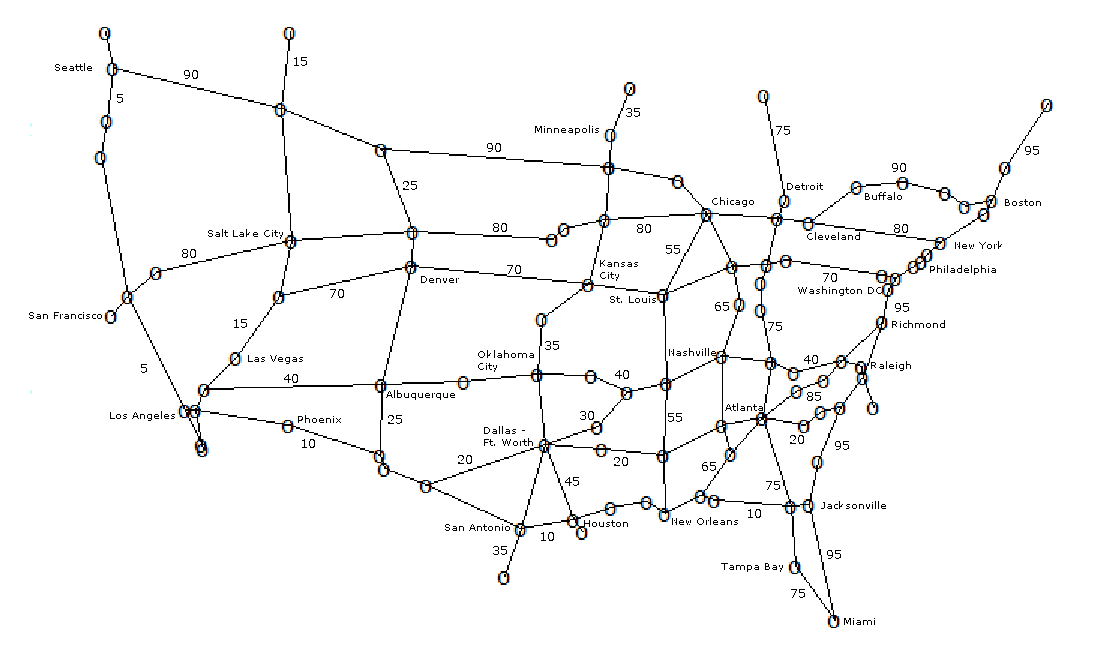
A few things to note are that there is no I-50 or I-60 and that I-80 and I-90 share a route through Indiana and Ohio. Also, I used the main city (such as L.A. or Chicago) as the point on the map, even where the interstate only went through the metro area or a suburb.
It's striking how even though this map is very minimalist, the outlines of the United States can be clearly seen , along with other details such as the more spread-out patterns of settlement west of the Mississippi (which is paralleled by I-55).
I made this map in R, then labelled it by hand because algorithms aren't good at placing labels for optimal legibility and clarity. Good map-making is a combination of an art and a science.
> Interstates <- read.csv("Interstates.csv")
> plot(Interstates$Long,Interstates$Lat,pch="o")
> lines(Interstates$Long[Interstates$I.5>0],Interstates$Lat[Interstates$I.5>0])
> lines(Interstates$Long[Interstates$I.10>0],Interstates$Lat[Interstates$I.10>0])
> lines(Interstates$Long[Interstates$I.15>0],Interstates$Lat[Interstates$I.15>0])
> lines(Interstates$Long[Interstates$I.20>0],Interstates$Lat[Interstates$I.20>0])
> lines(Interstates$Long[Interstates$I.25>0],Interstates$Lat[Interstates$I.25>0])
> lines(Interstates$Long[Interstates$I.30>0],Interstates$Lat[Interstates$I.30>0])
> lines(Interstates$Long[Interstates$I.35>0],Interstates$Lat[Interstates$I.35>0])
> lines(Interstates$Long[Interstates$I.40>0],Interstates$Lat[Interstates$I.40>0])
> lines(Interstates$Long[Interstates$I.45>0],Interstates$Lat[Interstates$I.45>0])
> lines(Interstates$Long[Interstates$I.55>0],Interstates$Lat[Interstates$I.55>0])
> lines(Interstates$Long[Interstates$I.65>0],Interstates$Lat[Interstates$I.65>0])
> lines(Interstates$Long[Interstates$I.70>0],Interstates$Lat[Interstates$I.70>0])
> lines(Interstates$Long[Interstates$I.75>0],Interstates$Lat[Interstates$I.75>0])
> lines(Interstates$Long[Interstates$I.80>0],Interstates$Lat[Interstates$I.80>0])
> lines(Interstates$Long[Interstates$I.85>0],Interstates$Lat[Interstates$I.85>0])
> lines(Interstates$Long[Interstates$I.90>0],Interstates$Lat[Interstates$I.90>0])
> lines(Interstates$Long[Interstates$I.95>0],Interstates$Lat[Interstates$I.95>0])
Here is the initial part of the "Interstates.csv" file I used with the R commands above (showing the portion for I-5; position along the interstate (from S to N or W to E) is numbered; Lat/Long is in decimal degrees):
Waypoint,Lat,Long,I-5,I-10,I-15,I-20,I-25,I-30,I-35,I-40,I-45,I-55,I-65,I-70,I-75,I-80,I-85,I-90,I-95
To Tijuana,32.544393,-117.031165,1,0,0,0,0,0,0,0,0,0,0,0,0,0,0,0,0
San Diego,32.708051,-117.156134,2,0,1,0,0,0,0,0,0,0,0,0,0,0,0,0,0
Los Angeles,34.051988,-118.133231,3,1,0,0,0,0,0,0,0,0,0,0,0,0,0,0,0
San Francisco,37.798441,-122.410388,0,0,0,0,0,0,0,0,0,0,0,0,0,1,0,0,0
Sacramento,38.552364,-121.493674,4,0,0,0,0,0,0,0,0,0,0,0,0,2,0,0,0
Eugene,44.055923,-122.987814,5,0,0,0,0,0,0,0,0,0,0,0,0,0,0,0,0
Portland OR,45.50626,-122.669211,6,0,0,0,0,0,0,0,0,0,0,0,0,0,0,0,0
Seattle,47.587558,-122.306662,7,0,0,0,0,0,0,0,0,0,0,0,0,0,0,1,0
To Richmond,49,-122.738862,8,0,0,0,0,0,0,0,0,0,0,0,0,0,0,0,0
....
The longest interstates are I-90 and I-80.
I think it would be interesting to do a roadtrip across the entire US someday following a single interstate.