Irrigation, untitled
Recently I read a few journal articles analyzing some historical instances of irrigation. My notes and some thoughts are shared below.
The first article was "Rome and Agriculture in Africa Proconsularis: Land and Hydraulic Development" by Arbia Hilali in Revue belge de philologie et d'histoire (2013). It gives a high-level overview of the development of agricultural lands in North Africa after Rome conquered it from Carthage. Hilali writes that,
The Romans were soon making their mark on the African landscape through the creation of a road network, the establishment of centuriation and the development of cultivation in terraces
As simple as it seems, terracing is a form of hydraulic infrastructure:
The objective of such an arrangement was to slow down the flow of water in order to retain it as long as possible, to avoid erosion, and to enrich the arable land through the accumulation of transported alluvium, which regenerates the fertility of the cultivable layer of soil.
A book I read a couple of years ago called Thirst had a fair bit to say about the use of terracing by ancient civilizations around the world.
Centuriation was a term I hadn't heard before. It refers to the Roman system of land surveying and division:
the aims of these surveying operations were to divide up the land, to specify the borders and the rights of the owners, to signal the quality of the land, (uncultivated land was not registered) and to fix fiscal norms and thus create a "fiscal space".
To the point about creating a "fiscal space", I'm reminded an insight that I think I gleaned from the book Free Market Environmentalism that property rights are legal infrastructure, and just like physical infrastructure it takes work to create and maintain them. Although I can't find the passage I'm thinking of, the next paper I read cited a different work by one of the same authors (Terry Anderson) with the following statement:
Studies of arrangements governing property in the frontier west have identified how better specified property rights tend to emerge as increasing scarcity transforms the situation from one of de facto open access to one where increasingly well-specified property rights bear returns that outweigh the costs of such rights' creation and enforcement.
According to the paper, some traces of centuriation can still be seen in Tunisia, such as in the hills around Mateur (near Lac Ichkeul). I find it interesting just how persistent original land surveys can be. There are some examples in Canada—not nearly as long-lived as these Roman ones, of course—that can be clearly seen on aerial photos that I thought I'd share:
- Granby, QC and the area to its southeast is part of the Eastern Townships; there is a clear difference in the shape of land parcels to the northwest, which were laid out according to the Seigneurial system
- Similarly, between Winnipeg and Selkirk MB, you can see the early lots (along the river) settled during the Red River Colony laid out in the manner of the Seigneurial system; away from the river, later waves of settlement had properties laid out on the square grid of the DLS.
Hilali's paper refers to records of land sales in Roman Africa, noting that,
the bills [of sale] of specify that the land was sold along with channels or reservoirs, which permitted cultivation
On a larger scale, the paper states:
it became clear that water and the construction of aquaducts are one of the key factors in the development of specific small areas.
Returning to the policy environment, Hilali describes how the Lex Manciana provided legal incentives to settle marginal land:
These regulations envisage conditions of tenancy for land that was not included in the centuriation lines and which was described as subseciva, owing to its uncultivated character (mountain, steppe and semi-desert areas).
Peasant farmers in such areas benefited from favourable conditions, being obliged to pay only a third of their crop to the landowners.
In addition to property rights and infrastructure (from aqueducts to field-scale irrigation channels), an important consideration for agricultural development in Roman Africa was the way it was tied into the markets and trade routes of the empire:
north Africa was one of the most dynamic regions of the Roman Empire and a source of exports, whether to Rome or to other provinces.
These factors (i.e. agricultural land is more valuable when it is surveyed (with the accompanying property rights), has infrastructure, and has access to markets) are summarized in the conclusion:
The topographic and hydraulic arrangements in Africa Proconsularis fit into an agricultural program. They reflect a deliberate policy to increase agricultural cultivation that formed the heart of a dynamic colonization scheme. ... agricultural cultivation was linked both to environmental considerations and to fiscal and legal incentives. ... The division of present-day parcels has retained much of the subdivisions of centuriae. ... By surveying the territories and transforming the agricultural landscape, the Romans succeeded in incorporating some African agricultural products in Mediterranean commercial circuits
The mention of Mediterranean agricultural products reminded me of a great museum I went to in Marseille called MuCEM.
The next paper looks at the effect on developing irrigation infrastructure when two factors—access to markets and clear title—come into conflict. It is titled "Development Derailed: Railroad Land Grants and Irrigation in the Western United States" and the authors are Eric Alston and Steven Smith (2019). The copy I read notes that it is a conference draft and not for general citation or circulation (hopefully something as informal as a blog post is okay); I don't know if it has been presented or published anywhere yet.
The topic of investigation was to:
examine the effects of uncertainty to title* on one costly economic activity along the frontier, irrigation development.
*this inspired the title of this post
Nineteenth-century railroads in the Western US raised the value of agricultural land by providing access to markets, but they were given entitlements to some of the land along their routes, which kept it in legal limbo until the railroad was constructed. The authors selected a railroad in Montana (the Northern Pacific = NP) that took a long time to complete (at a time when political and legal controversy over land grants to railroads was growing) as a case study to investigate the effect of uncertainty over (eventual) ownership on investment in improvements to the land. Specifically, irrigation works were considered as the improvement of interest, since irrigation is important for agricultural productivity in arid regions of the Western US like Montana, and because careful records were kept of irrigation diversions as higher-priority water rights went to early users under the prior appropriation rule.
The following excerpts explain the background of this case study that I've tried to summarize in the preceding paragraph:
Between 1850 and 1871, the federal government (and Texas) authorized the transfer of 158 million acres to private railroad companies. ... Upon certification of completion of a twenty-five mile section, the Land Office would issue patents for the odd-numbered sections of public lands lying on either side of the railroad right-of-way. (emphasis added)
The dominant paths to land title in the West [for individual settlers] were Homestead, Cash-Sales, and direct purchase from Railroads. ... But for the settler arriving in Montana between 1864 and, at minimum, 1894, it was unclear if any path to title would constitute a valid title on odd-sections within the land grant. If one was to pre-emptively purchase a parcel from the railroad before the NP received a patent, the settler took on the risk that the NP, having violated the terms of the land grant, would never receive a patent. Settling under the Homestead Act or a cash-sale from the government was an equally dubious proposition as the NP could ultimately argue the land had been reserved in the grant.
certainty to land title is an input to costly irrigation development because irrigation ditches are highly idiosyncratic investments given that the construction costs are sunk, location is important, and the ditch cannot be used for anything else
persistent difficulties in construction of the Northern Pacific and changes in General Land Office practices led to a large amount of lands being nominally withheld from settlement, which we argue had a persistent impact on the extent of irrigation in the state of Montana.
Thus, the comparative development of railroads and land policy in Montana and Colorado from 1864 to around 1920 provides a rich environment in which to test the effects of the interaction of land policy, ownership uncertainty, and railroad construction on irrigation development outcomes.
By giving railroads legal title to some of the parcels of land along their routes, the US government of the latter half of the 19th century provided an incentive for private companies to build infrastructure that didn't require a large outlay of money from the public treasury. The railroad companies would normally sell their parcels—which had increased in value since they now had good access to transportation—to recover construction costs. Although the government also benefitted from an increased tax base (as the railroads increased property values), these land grant subsidies were seen as overly-generous and became politically controversial. Alston and Smith also mention a scandal that increased the political controversy (In Canada, John A. MacDonald also had a scandal over railway financing).
In this political environment, and with delays in its construction, it was uncertain whether the Northern Pacific (NP) would get its land grants. The authors decided to use this uncertainty to test the economic theory that clear title/rights makes owners more likely to invest in improvements to a property:
Our main hypothesis is that the uncertainty surrounding the NP land grants in Montana suppressed investment in irrigation – a costly and asset-specific investment nearly necessary for agriculture in the region.
Alston and Smith use this case study as a clever natural experiment. As mentioned above, railroads in the western United States were given part of the land (odd-number parcels within a certain distance from the tracks) along their routes as an incentive for development. However, construction delays and a changing political environment made it unclear whether the Northern Pacific in Montana would benefit from this policy to the same extent. The authors were able to compare it to a railroad in Colorado that was finished on schedule (and before the land grants became controversial) and to another railroad in Montana that was built without subsidies.
They did some statistical analyses to investigate their hypothesis. One of these was a regression analysis looking at which factors about a PLSS parcel location (e.g. distance from a railroad, whether it was an odd-numbered section, etc.) explain variance in how much was irrigated and how early. Some of the key results are as follows:
land within the railroad grants in Montana have considerably smaller portions brought under irrigation by 1919 while Colorado land within its railroad grants were much more likely to have larger shares irrigated.
and,
water rights tend to be 4.3 years later within the railroad grant in Montana than the land beyond it. As a point of contrast, irrigation occurred nearly 8 years earlier on [railroad] land grant areas in Colorado
These two results are pretty convincing, in my opinion. Alston and Smith also emphasize that the date of first irrigation is carefully tracked because that establishes the priority/precedence of the water right under the prior appropriation rule, giving them reliable data to work with.
Another part of their analysis used the regression discontinuity method which they explain as follows:
The regression discontinuity method assumes that, other than change in policy imposed by the distance, the land on either side of the cutoff is similar along other dimensions.
Basically, parcels that are 51 miles from a railroad and parcels that are 49 miles from a railroad should be the same in almost every respect except the different policies that apply on either side of a 50 mile buffer (i.e. whether they are part of the potential land grant sections to the railroad). This threshold provides a natural opportunity to consider the impact of the policy environment while holding other factors constant.
I'm including a figure from their paper here for discussion purposes:
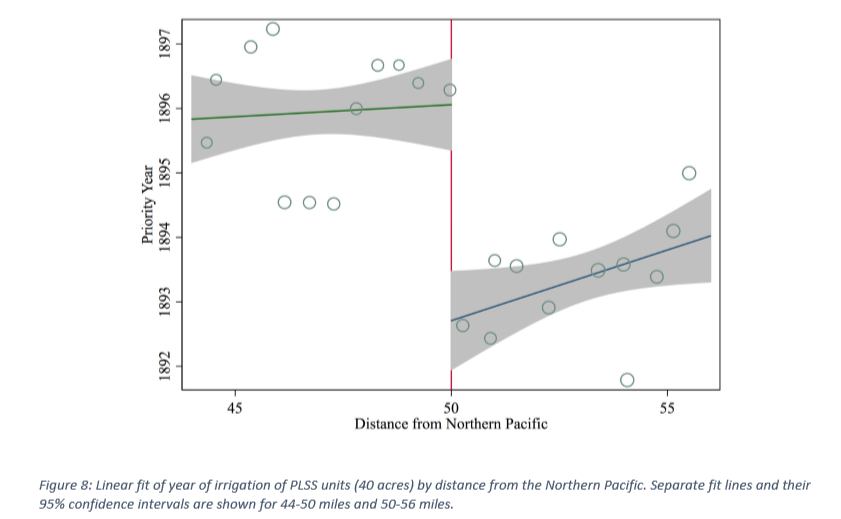
In their words, the analysis shows that,
There appears a stark change at the border and actual irrigation investment occurs years earlier just beyond the railroad grant lands in Montana.
This result lines up with the results of the previous analysis. To further solidify their findings, Alston and Smith did placebo tests at a different distance from the NT (where no legal change in status was applicable), at the same distance from the Great Northern (which had no land grants), and at the edge of the grant band of a railroad in Colorado (which didn't have the same uncertainty plaguing it). There did not appear to be a significant impact from the placebos, so they conclude that,
In sum, our tests provide a variety of evidence supportive of our general hypothesis: uncertainty surrounding railroad land grants in Montana had a persistent and negative influence on the extent and timing of irrigation development in the state.
This draft paper is very long; even with all of the excerpts and summarizing I've included above I've only touched on the highlights. Hopefully it can be made more concise for publication. I was very impressed by the mustering of data and the statistical analyses, especially the fact that they included placebo/robustness checks to make sure that they wouldn't get results that were just as significant in places where their hypothesis didn't apply as where it did.
Before moving on to the final paper I'll be discussing in this post, there are just a few more things from Alston and Smith's paper I wanted to note:
- Considerations about the sustainability of irrigation in arid regions were outside the scope of their study; they were just looking at irrigation works as a obvious indicator of investment in an agricultural property.
- One of the papers they cite is from 1911, along with a couple of retrospectives from a hundred years later like this one. (which I haven't read yet)
- This statement about why frontiers are a good location to study the impacts of factors like this was interesting:
Frontiers necessarily implicate questions of institutional change as private ordering is supplanted by a public legal system
The final paper I'm reviewing in this post is "Cooperation, Games, and Ecological Feedback: Some Insights from Bali" by J. Stephen Lansing & John H. Miller.
John Miller wrote one of the books on complexity I reviewed last year (and he discussed this paper in it).
Each of the papers I've looked at in this post is based in a different location and timeframe. The first one was in north Africa during Roman times, the second was in the American West in the late 19th century, and this one is in Bali and considers practices that likely developed over centuries but are still extant.
As Lansing and Miller describe it, rice farming in Bali faces two major challenges: there isn't enough water for the peak demand of all the farmers, and a variety of pests can consume a significant fraction of the harvest if their populations aren't checked. However,
Without centralized control, farmers have created a carefully coordinated system that allows productive farming in an ecosystem that is rife with water scarcity and the threat of disease and pests. ... the ecology of the rice farming system links these two externalities in such a way that cooperation, rather than chaos, results.
The water supply limitation can be mitigated by staggered planting (so one farmer's peak water demands will coincide with another's minimum water demands) while the pest threat can be mitigated by simultaneous planting (since pest populations will starve if fallow periods in nearby fields all occur at once).
The authors explain these conflicting goals:
If farmers with adjacent fields can synchronize their cropping periods to create a uniform fallow period over a sufficiently large area, rice pests are temporarily deprived of their habitat and populations can be sharply reduced.
Of course, if too many farmers follow an identical cropping pattern in an effort to control pests, then peak water demands will coincide. The existing watershed often does not have sufficient water to meet the full needs of all farmers in such a case.
From these considerations, they develop a game theory matrix, which I've included a copy of here (along with a couple of other figures from the paper that I'll be referring to below) for discussion purposes.
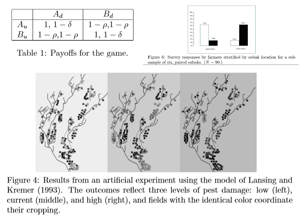
In this matrix, δ is the normalized crop loss to the downstream farmer due to reduced water and ρ is the crop loss from pests (affects both downstream and upstream farmers). A and B are choices of planting times and the subscripts d and u represent the downstream and upstream farmers, respectively. A full rice harvest with no impact from pests or water shortage is normalized to 1. Each cell contains the upstream farmer's harvest followed by the downstream farmer's harvest, separated by a comma.
The authors explain the implications of this matrix:
The expected aggregate crop yield from the mixed strategy is 2 - δ/2 - ρ. Two pure strategy equilibria (either both planting at time A or both planting at time B) arise when δ ≤ ρ.
A Nash equilibrium is when "no player can do better by unilaterally changing his or her strategy." That is, a vertical or horizontal move in the above matrix won't make either farmer better off under the conditions that Lansing and Miller state. However, under certain conditions (specifically when δ/2 < ρ < δ), the aggregate harvest (the sum of each farmer's harvest) could get better under certain conditions that would leave one of the farmers worse off—and therefore isn't a strategic equilibria. This leads to the theoretical outcome where cooperation is induced when damage from pests increases past a certain point:
If pest losses are low, the downstream farmer wants to stagger cropping due to water considerations while the upstream farmer wants to plant simultaneously to avoid pest damage ... If, however, pest losses are high, both farmers' incentives are to coordinate
the downstream farmer has no incentive to incorporate the pest damage to the upstream field in his decision calculus, and therefore it is possible for the downstream farmer to prefer staggered cropping even though this lowers aggregate yield.
On the other hand, it might be possible for the two farmers to come to a agreement where the upstream farmer passes on more water in exchange for the downstream farmer cooperating in controlling pests:
there are circumstances in which the upstream farmer may be willing to pass on some of the water in order to induce the downstream farmer to cooperate.
(I think the Coase theorem would have been very relevant to cite here)
They suggest that when farmers are motivated to cooperate (either outright or with some sharing of water), the local network of water temples provides a mechanism for arranging coordinated planting schedules.
The game theory model is a simple one (but sometimes simple models can be the most useful in reducing a phenomenon to its most salient points) so they move on to supporting that portion of the analysis with 3 lines of evidence. First was a "natural experiment" when a government mandate to grow more rice disrupted the traditional practice of local temples deciding planting schedules; next was an artificial experiment involving a detailed simulation of rice harvests in a district in which the authors tweaked the pest aggressiveness parameter; and last was a survey of farmers to see which ones were more concerned about pests and which ones were more concerned about water scarcity.
The natural experiment (i.e. not planned by the authors but a time in the historical record when a single factor was changed) took place during the Green Revolution in the 1970s. The government wanted to increase the agricultural output of the country. Here is how Lansing and Miller describe it:
To accomplish such a rapid change, the government legally mandated the double- and triple-cropping of these new [high-yield] varieties of rice. This led to the abandonment of the temple system of irrigation control, and therefore produced a situation where the previous coordination mechanism was rendered ineffective.
Soon after these mandated changes, district agricultural offices began to report "chaos in the water scheduling" and "explosions of pest populations"
The natural experiment of the breakdown of coordination during the Green Revolution provides support for the importance of coordination mechanisms in this system. The ecosystem is such that without careful coordination it experiences massive crop losses, and ultimately lower aggregate output, due to exploding pest populations. This resulted in strong pressure from the farmers to re-institute coordination mechanisms despite resistance from consultants and officials supporting the modernization program.
The simulation results used in the artificial experiment and some of the survey results are included in the image I shared above. In the simulation model, each subak (a group of farmers) in the model copies the best of its four neighbours for its cropping pattern in the following year (this seems reminiscent of cellular automata rules); the model also includes hydrological (water availability) and biological (growth of rice and pests) components. In Figure 4, planting times become more coordinated (shown with clusters of subaks all having the same symbol) between neighbours as pest damage increase (from left to right). In Figure 6, survey results from paired upstream/downstream subaks show a higher relative concern over pests in upstream subaks and a higher relative concern over water shortages in downstream subaks. Both of these results line up with the strategic considerations from the game theory model.
Here is how Lansing and Miller conclude:
Without centralized control, farmers have created a coordinated system that allows productive farming in an ecosystem that is rife with water scarcity and the threat of disease and pests. The game-theoretic model we develop above, inspired by a generation of extensive anthropological field work*, provides a compact explanation for many of the most salient features we observe in the system.
While externalities caused by either water scarcity or pests, would, in isolation, be expected to imply a serious failure, the ecology of the rice farming system links these two externalities in such a way that cooperation, rather than catastrophe, is the result.
*we should all be so lucky to have field work in Bali.
Overall, I thought this was a very good paper. I feel like I understand game theory a bit better after seeing this application that is a step up in complexity from the regular example of the Prisoners' Dilemma. Validating the strategic insights of the game theory analysis with three distinct avenues of evidence (a historical disruption used as a natural experiment, a more complex simulation, and field surveys) strengthens their results a great deal. The account of pest populations ballooning during the Green Revolution is a good reminder that local knowledge shouldn't be too quickly ignored by experts.
For one of my next posts, I think I might have more to say about this last point (and also have more to say about Coase, who I briefly mentioned in the above discussion).