Cartography in the Wardrobe
The Chronicles of Narnia is one of my favourite children's series. Every good fantasy novel is incomplete without a map. While the Narnia books include some maps, they tend to focus on the area where each book is set; there is a comprehensive map in the back of some editions, but it is in colour (rather than the more typical style of fantasy maps) and hard to find in high resolution. So I thought it would be fun to try assembling a comprehensive map of Narnia.
Here's the map I came up with (right click and open it in another tab to zoom in for more detail):
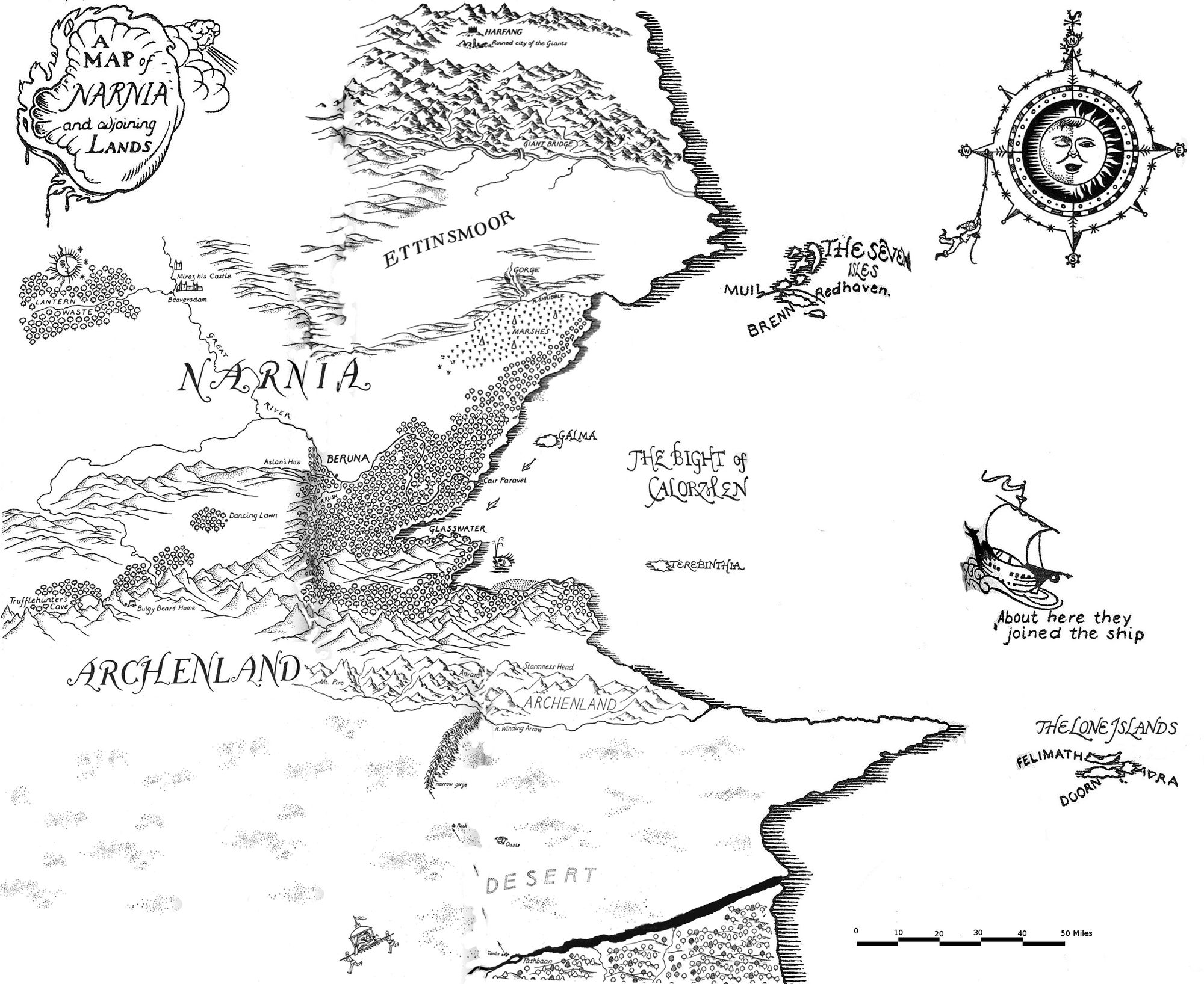
To make this map, I overlaid 4 maps from different books (The Horse and His Boy, Prince Caspian, The Voyage of the Dawn Treader, and The Silver Chair) in the GNU Image Manipulation Program, using the transparency function to assist with placement. I erased overlapping parts to try to keep the best details in each area. Finally, I used the cloning tool and did some manual touch-ups to smooth things out and fill in the white space a bit more.
Here's what it looked like when it was a work in progress. The contributions from the four different maps can be seen:
Something notable about the maps of Narnia (considering it's in the genres of fantasy and children's literature) is that the scale is realistic. The country of Narnia itself is around 90 miles from East to West and 60 miles from North to South. If it was rectangular, its area would be 5,400 sq. mi., or about the size of Montenegro. It centres on a fertile river valley and is hemmed in by hills/mountains on the three sides that aren't coastal. In the following paragraphs, I'll discuss some of the key places and journeys from the seven books in the series, and compare them to real-world geography where applicable.
In The Magician's Nephew, most of the action in Narnia takes place around [the future location of] Lantern Waste in the northwest. There is also a visit made to a garden in the mountains far to the west (not shown on this map). The return leg of the journey takes most of a day until sunset, flying on a pegasus. Assuming 12 hours at a flight speed similar to an eagle (50 km/h), that distance would be up to 375 miles (600 km)—much more than the width of Narnia proper. This first book in the series also gives an aerial view of the lay of the land:
All Narnia, many-coloured with lawns and rocks and heather and different sorts of trees, lay spread out below them, the river winding through it like a ribbon of quicksilver. They could already see over the tops of the low hills which lay northward on their right; beyond those hills a great moorland sloped gently up and up to the horizon. On their left the mountains were much higher, but every now and then there was a gap when you could see, between steep pine woods, a glimpse of the southern lands that lay beyond them, looking blue and far away.
"That'll be where Archenland is," said Polly.
"Yes, but look ahead!" said Digory.
For now a great barrier of cliffs rose before them and they were almost dazzled by the sunlight dancing on the great waterfall by which the river roars and sparkles down into Narnia itself from the high western lands in which it rises. ...
"I say, look back! Look behind," said Polly.
There they could see the whole valley of Narnia stretched out to where, just before the eastern horizon, there was a gleam of the sea. And now they were so high that they could see tiny-looking jagged mountains appearing beyond the northwest moors, and plains of what looked like sand far in the south.
The second book in the series is the best known: The Lion, The Witch, and the Wardrobe. It starts in Lantern Waste. After that, most of the key events take place along the Great River. Miraz' castle hasn't been built by this point, but three of the Pevensie children initially go to the Beavers' lodge at the nearby confluence and the other child, Edmund, goes to the White Witch's castle a short distance north/upriver. The climax occurs at Aslan's How (the Stone Table at that point in time); it is followed by a battle at Beruna and a coronation at the castle of Cair Paravel on the coast.
The third book, The Horse and His Boy, is one of my favourites. It is also the one that involves the most travel and is thus well-suited for discussing with reference to a map. It starts off in the country of Calormen to the south of Narnia. It is a much bigger country: Shasta and Bree take weeks to reach the capital of Tashbaan on the northern border, and they didn't even start from the southern extremity. So Calormen is a few hundred miles from north to south at a minimum. From Tashbaan, they cross the desert to Archenland in the mountains on Narnia's southern border. The desert is about 60 miles wide according to the map, but their route leads them to a narrow gorge (easy to overlook if you don't know about it) where they can find water and shade, getting out of the fierce desert conditions after only 45 miles or so. They started their journey across the desert after midnight, and it was well after dark by the time they reached the gorge; the travel speed seems realistic including breaks. The width of the desert also seems realistic for providing a military buffer between the Calormen empire and the much smaller independent kingdoms of Archenland and Narnia. A Calormen prince brings a small force across the desert to attack Archenland, but larger armies have slower movement speeds, and the necessity to carry enough water quickly makes the logistics prohibitive unless the desert can be crossed quickly. There is some interesting discussion about these logistics here:
And small groups of cavalry, if they ride hard and bring spare horses (and they do) can move very fast. As I’ve noted before, the Mongols manage strategic movements over long periods up to 60 miles per day, but then, they are the Mongols.
(I also recently read a book titled The Secret History of the Mongol Queens, and it mentioned how they had a military advantage by being able to conduct military operations across the Gobi Desert, unlike the settled peoples to the south of it).
The mountain range containing the tiny kingdom of Archenland appears to be 25 to 40 miles wide from north to south. The core area around the castle of Anvard probably isn't much bigger than Andorra (180 sq. mi.), although they are nominally sovereign over much of the range. A good comparison for the size of this mountain range is probably the interior of Wales; the Appalachian mountains in Pennsylvania are a bit more extensive (it's 65 miles from Harrisburg to Williamsport), but also in the right order of magnitude.
The Prince Caspian era (which covers that book and the next two) is when the map above is most valid. Caspian was the tenth of his name. Comparing the timeline of French kings (King Louis X reigned c. 1300 while King Louis I reigned c. 825), the Telmarine invasion of Narnia had probably been almost 500 years before his time. The castle where he was raised (Miraz' castle) had been built by his great-great-grandfather, likely 80 - 100 years earlier. The land of Telmar isn't shown on this map, but seems to have been to the southwest. In Prince Caspian, the Pevensie children (and a dwarf they meet) row from Cair Paravel up the Glasswater, then travel overland to Aslan's How. The walking part of their journey would have been about 30 miles; they stop to camp a couple of times, but the slow speed makes sense considering they were travelling through a dense woods and had to backtrack due to obstacles.
The Voyage of the Dawn Treader is the only book in the series that takes place on the ocean and islands of Narnia. This part of the map seems like it is not to scale. The Dawn Treader sailed from Cair Paravel to Galma (20 miles on the map) in a day; Galma to Terebinthia (40 miles on the map) took 4 days but required rowing due to not having favourable winds; it took 8 days to sail from Terebinthia to the Seven Isles (75 miles on the map); it also took 8 days to travel from the Seven Isles to the Lone Isles (140 miles on the map), but the book mentioned that they were making very good speed. It was on this last leg that Lucy, Edmund, and Eustace joined the ship, 6 days and 400 leagues after it had left the Seven Isles. The distances on the map imply a speed of around 10 to 20 miles per day—less than one mile per hour. However, pre-modern ships could sail at around 4 knots / 4.5 mph; furthermore, covering 400 leagues (1200 nautical miles) in six days as the book says means that the Dawn Treader can sail at over 8 knots (fast but achievable for a sailing ship). The discrepancy between distances on the map and what is stated in the text (which aligns better with plausible sailing speeds) suggests that the ocean part of the map above is not to the same scale as the land portion. A possible reason for the difference in scale could be that the islands are shown at the right latitude but the longitude is depicted less precisely. Pre-modern navigational instruments were, in fact, much better for measuring latitude than longitude (although given that Narnia is canonically a flat world, I don't know how celestial navigation techniques would translate).
The Silver Chair is the only book to explore the lands north of Narnia. Eustace and Jill meet up with a marshwiggle named Puddleglum in the big marsh in the northeast of Narnia, then travel north to the land of giants (Harfang castle and its surroundings) through the moorlands and mountains. They end up in an underground kingdom and eventually end up back in Narnia. I wish the book had spent more time exploring the marsh, since wetlands are a biome I'm fond of.
The action in the final book, The Last Battle, doesn't travel around as much as the others; it mainly takes place in a few locations in the vicinity of Lantern Waste. The Ape that is the villain of that book initially lives in a treehouse by the waterfall that marks the western border of Narnia. It is not shown on the map above, but was mentioned in the excerpt from The Magician's Nephew. The waterfall is on the branch of the Great River that flows through Lantern Waste. The barn where the Ape sets up his headquarters is also more-or-less in the vicinity of Lantern Waste. This book is set 200 years (7 generations between Tirian and Rilian) after The Silver Chair.
If you enjoyed this post, then you may be interested in this article about the history of the typical style of fantasy maps (and the author has a whole category about fantasy maps on his blog). And someone made a map of my hometown in that same style.