fietspaden en droge voeten
This is my final post based off of my trip to the Netherlands. It focuses on reviewing a book about land reclamation and flood control infrastructure in the Netherlands and sharing a couple of bike trips I took out into the countryside around Amsterdam and Rotterdam to see some of this infrastructure, among other things.
Designed for Dry Feet by Dr. Robert Hoeksema is a book about flood control and land reclamation infrastructure in the Netherlands. It is based on a field course the author taught; it seems to be written for an engineering audience, but the content is accessible enough for anyone with an interest in the topic. I read it on my trip and found it increased my insight and appreciation for the landscapes I was seeing. The topic of the book was also timely closer to home, given the 2018 floods in New Brunswick.
Designed for Dry Feet has ten chapters. The first one provides a historical overview. The next seven chapters delve into specific types of flood protection or land reclamation technologies, or projects in specific parts of the country. These range from building mounds to locate the cores of settlements above flood plains, to the creation of an entire province on reclaimed land in the 20th century. The second last chapter discusses the governance of this infrastructure by water management boards and a national authority. The final chapter lays out some suggested self-guided driving itineraries for seeing many of the sites mentioned in the book.
I'm going to start by sharing Dr. Hoeksema's definition of a "polder" since it is key to understanding the Dutch landscape:
Today’s Dutch lowland landscape consists of hundreds of water management units called polders. A polder is an area completely isolated from the surrounding area, usually by a berm, dike, or embankment, in which the groundwater levels are artificially controlled. This control involves a variety of drainage schemes—usually ditches and canals that deliver the water to the perimeter of the polder. The water is then released from the polder using a pump or sluice. A pump is needed if the water outside the polder is always higher than the water inside the polder. If the water outside the polder is occasionally lower than the water inside, then a sluice can be used. (p. 1)
Before polders began to be used, there were efforts to increase the amount of useful land by draining peaty areas (a lot of peat was also harvested for fuel or for salt extraction). However, soils—especially water-logged peat—inevitably subside/compact when they are dried out. Thus a lot of these early efforts inadvertently created lakes (e.g. near Haarlem and Beemster); these lakes caused a lot of erosion of the surrounding areas when winds off the North Sea whipped up large waves.
The next step in land reclamation was building dikes around areas that were sometimes (e.g. at low tide) above water level and letting them drain through sluices that would close to prevent flow back in when water levels rose. Only later did active drainage (with windmills and later steam or diesel pumps) come into play. Until reading this book and travelling to the Netherlands, I didn't realize just how much of the land there has been reclaimed. This .gif provides a visual summary.
The basic approach to reclaiming land into a polder was as follows:
To successfully drain a lake, those in charge of the project had to follow several steps. First, they cut off any connections to and from the lake and redirected existing streams around the lake. Next, they dug a ring canal around the perimeter of the lake and used the spoils from the canal to build a dike between the canal and the lake water. In some places, low areas on the outer side of the canal were also filled. Next, an outlet for the ring canal was found. Outlet canals were usually dug connecting the ring canal to a receiving water body. (p. 35)
I was impressed by this excerpt from the contract for Beemster polder (from the early 17th century) because including a performance test is a savvy feature in contracts even today:
And to make sure that the reclamation can be carried out by means of sixteen windmills for drainage, the contractors have accepted and promised, just as they hereby accept and promise, that they will pass tests of their invention full-size, in the presence of the Delegates of the Landowners in the polder within a period of four weeks at most. And if it is found that the sixteen windmills for drainage are not capable of doing the work, the contractors will be held to provide themselves immediately with more old or new windmills up to the number the Delegates see fit. (p. 45)
Windmills are believed to have been invented in the Middle East, but the technology was heavily improved and refined in the Netherlands. Designed for Dry Feet describes different types of windmills, such as tower mills (where only the cap at the top is rotated to face the wind) and post mills (where the entire mill house can be rotated to face the wind). Windmills were applied to grinding grain and then adapted for pumping water out of polders.
Some men who were influential in the development of land reclamation practices during this era were Vierlingh, Stevin, Leeghwater, and (a bit later) Cruquius.
This post will get too long if I try to talk about everything, so I'm going to skip over coastal flood protection and the huge undertaking reclaiming land from the Zuiderzee (a 50 year project that increased the amount of land in the country by 5%). Those sections were certainly interesting, but they're about parts of the country I didn't really get to see on this trip.
Perhaps the most interesting chapter in Designed for Dry Feet is about the Delta Works project. It consisted of the construction of a number of dams and barriers throughout the delta (of the Rhine–Maas system) in the southwest of the country. The structures involved are shown in the following diagram (used here for review purposes only):
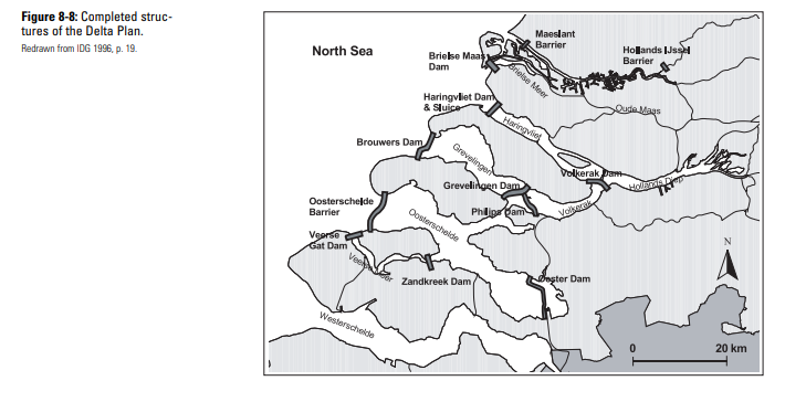
The trigger for the Delta Works project was a huge flood in 1953, brought on by a storm surge that coincided with a spring tide, that killed over 1800 people. It was finally completed in 1997 (the original plan was to finish in 1978). Because this work occurred more recently than many of the other projects in the book, Dr. Hoeksema is able to provide a lot of detail on how it was implemented. The smaller structures were constructed first, allowing the lessons learned from them to be applied to larger challenges. During the liberation of Holland at the end of the Second World War, the Allies bombed some dikes. The gaps were closed by sinking excess military hardware. This technique was adapted for the Delta Works, with pre-fabricated caissons being floated into place than sank and filled for the constructions of barriers and dams. Other techniques included preparing the river- or sea-bed by placing fascine mattresses, and building up causeways with cable suspended rock drops.
Blocking flow from the sea had some unintended environmental consequences, so the plan for the project was adapted (one of the benefits of proceeding one stage at a time!) so that some of the main barriers would be normally open and only close when necessary to prevent inland flooding (e.g. during storm surges):
In the early 1970s changes were made in the design of the Oosterschelde Dam. Concerns were raised about the impact that this structure would have on the unique Oosterschelde estuary environment. The clean, salty water of the Oosterschelde provided a rich feeding ground for many types of animals. Mussel and oyster farming took place in this area on a large scale. The mud flats, salt marshes, and sandbars were an important habitat for birds. ... This rising concern about the environment sparked a great national debate about the direction to be taken in the Delta. Should the Delta Plan continue with its philosophy of safety over everything else or should accommodations be made for the environment? This question was answered with a redesign of the entire Oosterschelde Dam. Instead of a structure that created a permanent barrier, an open structure was built. The new barrier design allowed the tides to continue to flow in and out of the Oosterschelde and closed the area off only in the event of a storm at sea. The new barrier design used 62 steel gates, which could be raised or lowered in the event of a large storm. (p.115)
In addition to the hard infrastructure built as part of the Delta Works, there is now a policy called "Room for the River" that seeks to reduce damage from flooding by leaving more space as a floodplain.
I didn't rent a car during my trip, but I still wanted to see some of the places Dr. Hoeksema described. So I found ones that were close enough to the cities I was staying in that I could see them while out biking for the day. In the next part of this post, I'll describe the routes I took and some things I saw, especially as it relates to what's in the book. Whether or not these specific routes appeal to you or not, one of my top recommendations for anyone else going to the Netherlands is to get on two wheels and spend some time outside of the cities.
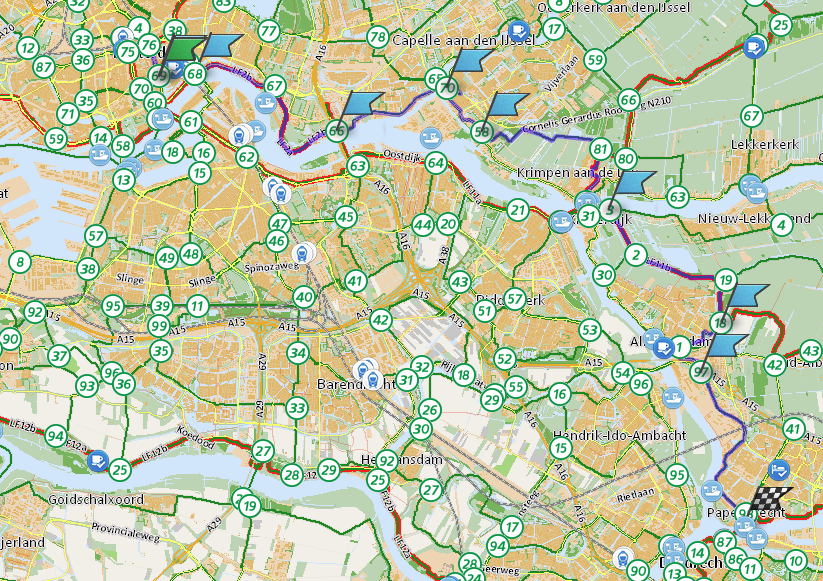
The Netherlands has a great network of bike paths with good signage that makes it easy to navigate. This website has a convenient tool for planning routes. I used that tool to make the following map of the approximate loop I took from Amsterdam (and the one below from Rotterdam):
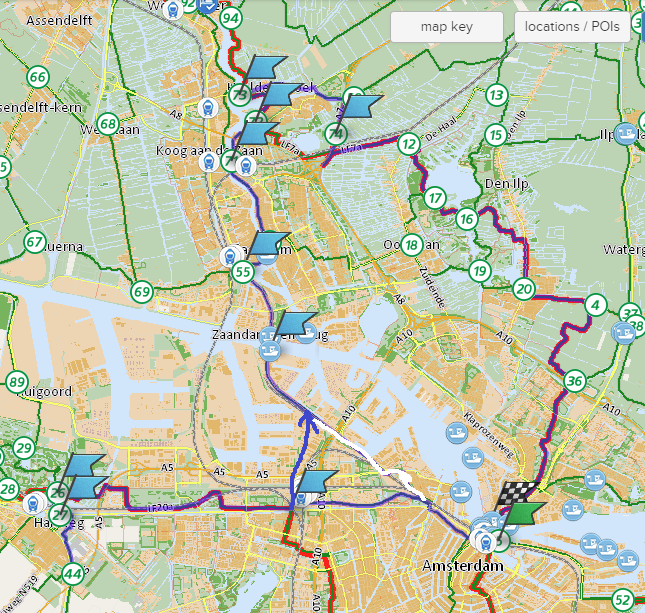
Leaving from Centraal Station, I started heading west. I went through Westergaspark then parallel to a highway to reach the town of Halfweg. There is a steam-powered pumping station with a little museum that is mentioned in Designed for Dry Feet there (unfortunately, it was closed when I went). I then crossed a bridge over the ring canal into the Haarlemmermeer polder (at Zwanenburg). It's hard to capture in a photo, but in person you can easily notice that the land inside the polder is lower than the water in the ring canal. Other pumping stations lift water from drainage ditches inside the polder to the ring canal (the one at Halfweg was used for lifting water from the ring canal to a level where it could drain to the Noordzeekanaal, I believe). From Halfweg, I headed back toward Amsterdam but turned north and went past the OBA bulk terminal to catch the ferry (free for cyclists) to Zaandam. Biking through the town got me to the attraction of Zaanse Schans, where there are a number of operational windmills, along with other aspects of traditional Dutch rural regions on display (such as a cheese shop). I went in a couple of windmills that were making mustard and pigments. These windmills were not described in the book as they are used for milling rather than pumping, but a lot of the features are similar.
On the way back to Amsterdam, I mostly followed the LF7 route (one of the national long distance cycle routes). It goes through some beautiful countryside including through Twiske park, past a memorial to some Allied airmen who died in WW2, and then along the Noordhollandsch Kanaal.
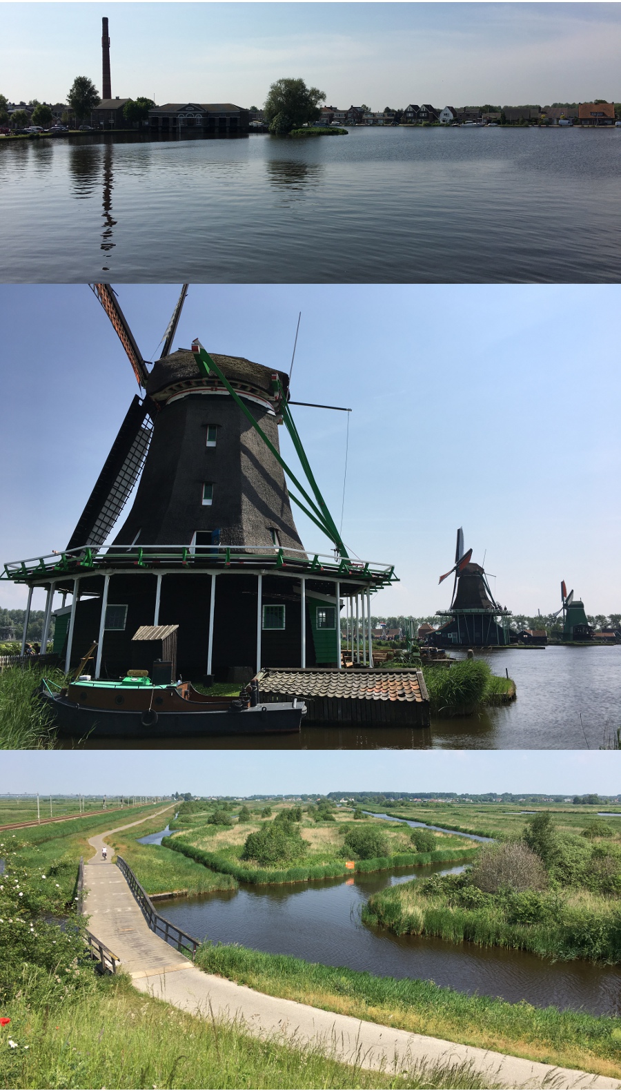
Here are a few photos from this biking excursion. From top to bottom, it shows the pumping station at Halfweg, windmills at Zaanse Schans, and some of the landscape along LF7:
Here are some other ideas for biking day trips around Amsterdam.
Here is the approximate route I took when I went biking from Rotterdam:
After renting a bike, I started by going to Station Hofplein to get some breakfast (from Lokaal Koffie). That is where the crowdfunded bridge I mentioned in my post on Rotterdam is located. After fueling up for the ride, I headed out of Rotterdam along the north bank of the Nieuwe Maas. My first destination was the Hollandse IJssel storm surge barrier, which was the first structure in the Delta Works project. Next I continued through some fields to Krimpen aan de Lek where I took a ferry across to Kinderdijk. The polder landscape I was biking through is really unique and quite lovely. It’s basically not at all "natural", but I’m not sure I’ve seen such a diversity of waterfowl anywhere else. There are also plenty of cows, goats, and sheep—grass-fed so they'll make delicious cheese, presumably. At Kinderdijk there are 19 traditional windmills still in operation; they comprise a UNESCO World Heritage Site. These windmills lift water from the polders on either side to storage canals ("boezems"). More modern pumps are used to perform the second lift into the Lek river so it can drain to the ocean. During the disastrous flood of 1953 the fields in this area were under at least 3 or 4 metres of water; a level stick by one of the windmills showed the dramatic height of the floods as well as the normal level of the river, which still requires a significant lift to drain the fields.
The route I took was great with respect to seeing places mentioned in Designed for Dry Feet because I was able to see a traditional site at Kinderdijk as well as a modern flood protection barrier (part of the Delta Works project) at Krimpen aan de IJssel, all in a short bike ride from Rotterdam. I was enjoying the biking, though, so I decided to extend the route by continuing on to Dordrecht. At Papendrecht, I caught the waterbus across to Dordrecht, then transferred to the one to Rotterdam. The waterbus was a fun way to travel, especially on stretches of the Maas where there is room for the pilot to open up the throttle.
Here are some photos I took along this bike route, showing the storm surge barrier, windmills at Kinderdijk (there were some behind me that lift water from the lower drainage ditch on the right to the "boezem" on the left; the visible windmills on the left pump into another boezem that is obscured by tall grass), and travelling back to Rotterdam on the Waterbus:
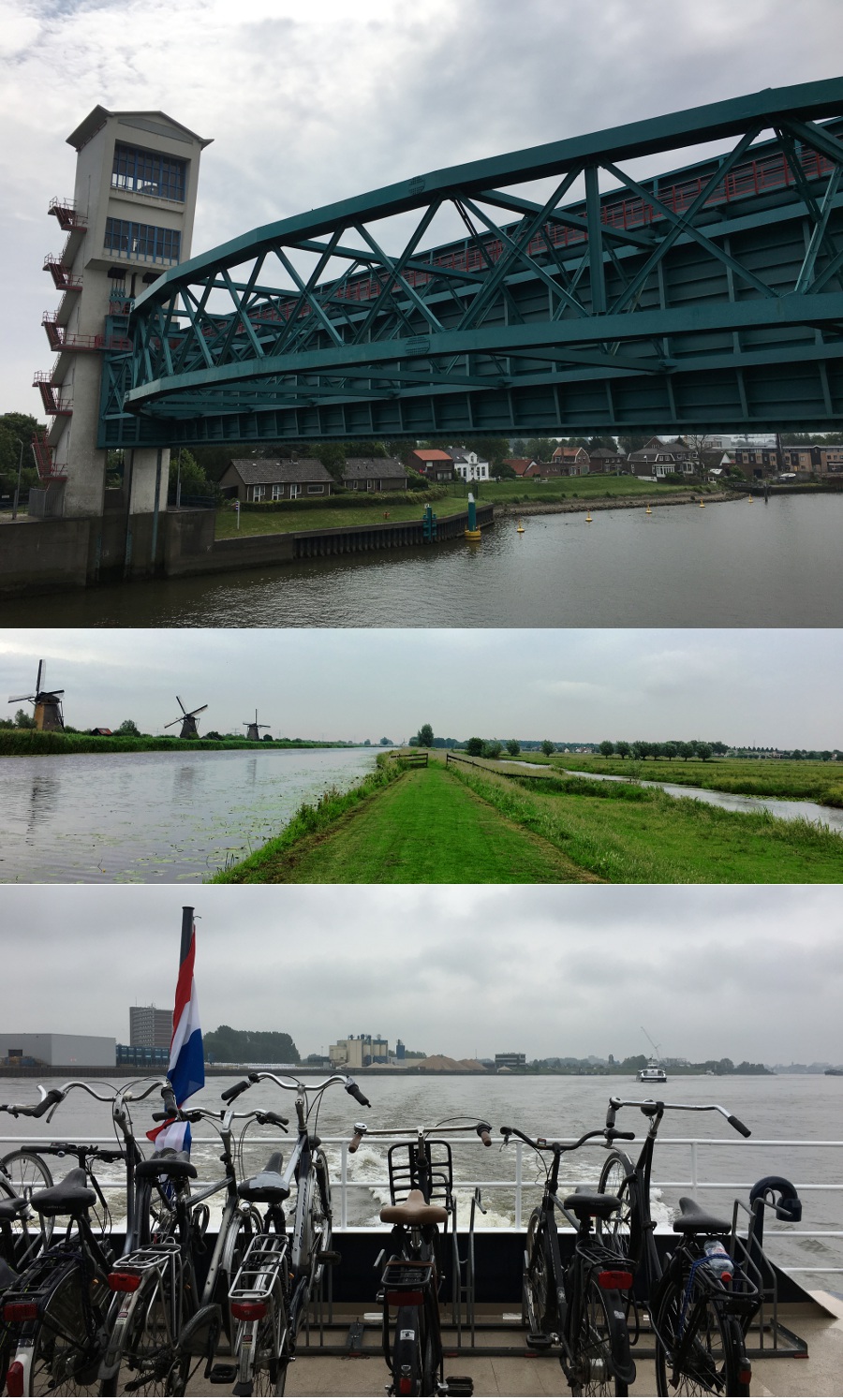
Here is Dr. Hoeksema's description of the Hollandse IJssel Storm Surge Barrier. He includes a similar description for each recommended site to visit:
This was the first structure completed as part of the Delta Plan. It is a storm barrier used to close off the Hollandse IJssel River. There is no visitor’s center or exposition, but there are good places to get a close look at this structure. (p.122)
Here are some other ideas for biking excursions around Rotterdam.
I'll note that I also briefly saw the Maeslant storm surge barrier—the last structure in the Delta Works project to be completed—when the bus (#713) back from the beach at Hoek van Holland drove past it. It consists of two halves that can be swung into place and then sunk to block the flow. Apparently the ball joints at the pivot points have a 10 metre diameter.
There were many places described in Designed for Dry Feet that I didn't see on this trip, but would like to someday. Some of the spots that stand out are more of the Delta Works structures in Zeeland, the Biesbosch national park in an area that is not reclaimed (it used to be settled but the dikes were destroyed in a flood in 1421 and not rebuilt), some of the coastal dunes and dikes, and places around Flevoland like the Ramspol inflatable dam and the Oostvaardersplassen nature reserve in an artificial environment (lack of predators is an issue there apparently). Also Friesland and the Waddenzee, and the artificial land extending the Port of Rotterdam.
The Dutch are justly famous for maximizing the useable space in a country that would be mostly underwater if nature took its course; the techniques and projects discussed in Designed for Dry Feet show how they've done that through the centuries. Looking forward, the approach may shift to floating architecture—building on the water instead of trying to remove it. Seasteading mentioned some examples, such as the floating pavilion I showed a picture of in my post on Rotterdam and a neighbourhood in Amsterdam that includes a number of floating houses. I took the tram (line 26) to take a look at this neighbourhood (Steigereiland) while I was in Amsterdam:
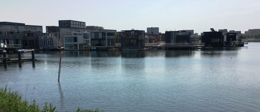
Perhaps neighbourhoods like this will become more common as Dutch efforts to keep their feet dry continue.
If you found this post by searching for "historic caissons", or something along those lines, then you may be interested in a presentation I saw at a conference last month:
"Case Study: History and Refurbishment of 145-Year-Old Rail Bridge Piers, Southwest Miramichi River Bridge in Miramichi, NB", CSCE 2018.
The famous engineer Sandford Fleming was involved in the original project and preserved detailed notes. The authors also managed to find some archival photos of these bridge piers under construction, some of which are included in the linked paper (although the presentation had more) and it was fascinating to see the construction techniques of that era.
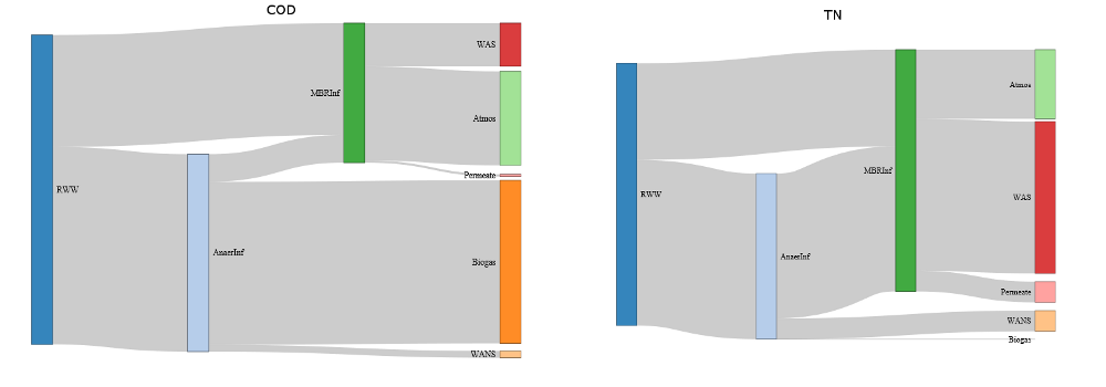
I also had a short case study to present at this conference. I made some Sankey diagrams (following this tutorial) for it, although the timeslot was too short to use them in my presentation: